You are here: Home > Network List > US - United States National Seismic Network Stations List
> Station ERPA Erie, Pennsylvania, USA > Earthquake Result Viewer
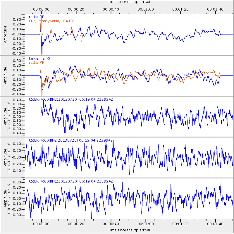
ERPA Erie, Pennsylvania, USA - Earthquake Result Viewer
*The percent match for this event was below the threshold and hence no stack was calculated.
| Earthquake location: |
Near East Coast Of Honshu, Japan |
| Earthquake latitude/longitude: |
36.3/141.7 |
| Earthquake time(UTC): |
2013/07/20 (201) 06:06:22 GMT |
| Earthquake Depth: |
14 km |
| Earthquake Magnitude: |
5.5 MB |
| Earthquake Catalog/Contributor: |
NEIC PDE/NEIC PDE-W |
|
| Network: |
US United States National Seismic Network |
| Station: |
ERPA Erie, Pennsylvania, USA |
| Lat/Lon: |
42.12 N/79.99 W |
| Elevation: |
306 m |
|
| Distance: |
93.2 deg |
| Az: |
29.708 deg |
| Baz: |
327.424 deg |
| Ray Param: |
$rayparam |
*The percent match for this event was below the threshold and hence was not used in the summary stack. |
|
| Radial Match: |
33.188694 % |
| Radial Bump: |
400 |
| Transverse Match: |
45.66461 % |
| Transverse Bump: |
400 |
| SOD ConfigId: |
512894 |
| Insert Time: |
2013-09-15 22:51:48.948 +0000 |
| GWidth: |
2.5 |
| Max Bumps: |
400 |
| Tol: |
0.001 |
|
Signal To Noise
| Channel | StoN | STA | LTA |
| US:ERPA:00:BHZ:20130720T06:19:04.223994Z | 0.94594127 | 1.6955582E-7 | 1.7924562E-7 |
| US:ERPA:00:BH1:20130720T06:19:04.223994Z | 0.8584036 | 1.481972E-7 | 1.726428E-7 |
| US:ERPA:00:BH2:20130720T06:19:04.223994Z | 0.9535617 | 1.6167819E-7 | 1.6955188E-7 |
| Arrivals |
| Ps | |
| PpPs | |
| PsPs/PpSs | |


