You are here: Home > Network List > GT - Global Telemetered Seismograph Network (USAF/USGS) Stations List
> Station PLCA Paso Flores, Argentina > Earthquake Result Viewer
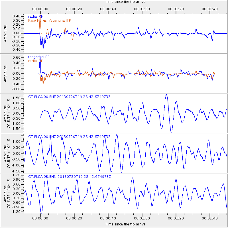
PLCA Paso Flores, Argentina - Earthquake Result Viewer
*The percent match for this event was below the threshold and hence no stack was calculated.
| Earthquake location: |
Cook Strait, New Zealand |
| Earthquake latitude/longitude: |
-41.6/174.4 |
| Earthquake time(UTC): |
2013/07/20 (201) 19:17:10 GMT |
| Earthquake Depth: |
14 km |
| Earthquake Magnitude: |
5.7 MW, 5.6 MS, 5.8 MB, 5.9 MW |
| Earthquake Catalog/Contributor: |
NEIC PDE/NEIC PDE-W |
|
| Network: |
GT Global Telemetered Seismograph Network (USAF/USGS) |
| Station: |
PLCA Paso Flores, Argentina |
| Lat/Lon: |
40.73 S/70.55 W |
| Elevation: |
1050 m |
|
| Distance: |
79.1 deg |
| Az: |
135.493 deg |
| Baz: |
223.745 deg |
| Ray Param: |
$rayparam |
*The percent match for this event was below the threshold and hence was not used in the summary stack. |
|
| Radial Match: |
51.266953 % |
| Radial Bump: |
400 |
| Transverse Match: |
52.56412 % |
| Transverse Bump: |
400 |
| SOD ConfigId: |
512894 |
| Insert Time: |
2013-09-15 22:59:54.124 +0000 |
| GWidth: |
2.5 |
| Max Bumps: |
400 |
| Tol: |
0.001 |
|
Signal To Noise
| Channel | StoN | STA | LTA |
| GT:PLCA:00:BHZ:20130720T19:28:42.674973Z | 1.2404766 | 7.648908E-7 | 6.1661035E-7 |
| GT:PLCA:00:BHN:20130720T19:28:42.674973Z | 1.7521979 | 8.6920693E-7 | 4.9606666E-7 |
| GT:PLCA:00:BHE:20130720T19:28:42.674973Z | 1.0812973 | 3.9093004E-7 | 3.6153799E-7 |
| Arrivals |
| Ps | |
| PpPs | |
| PsPs/PpSs | |


