You are here: Home > Network List > IU - Global Seismograph Network (GSN - IRIS/USGS) Stations List
> Station HNR Honiara, Solomon Islands > Earthquake Result Viewer
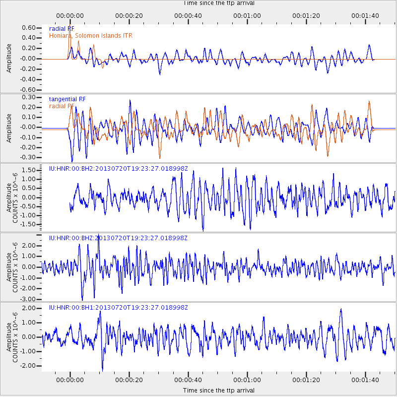
HNR Honiara, Solomon Islands - Earthquake Result Viewer
*The percent match for this event was below the threshold and hence no stack was calculated.
| Earthquake location: |
Cook Strait, New Zealand |
| Earthquake latitude/longitude: |
-41.6/174.4 |
| Earthquake time(UTC): |
2013/07/20 (201) 19:17:10 GMT |
| Earthquake Depth: |
14 km |
| Earthquake Magnitude: |
5.7 MW, 5.6 MS, 5.8 MB, 5.9 MW |
| Earthquake Catalog/Contributor: |
NEIC PDE/NEIC PDE-W |
|
| Network: |
IU Global Seismograph Network (GSN - IRIS/USGS) |
| Station: |
HNR Honiara, Solomon Islands |
| Lat/Lon: |
9.44 S/159.95 E |
| Elevation: |
100 m |
|
| Distance: |
34.5 deg |
| Az: |
334.263 deg |
| Baz: |
160.737 deg |
| Ray Param: |
$rayparam |
*The percent match for this event was below the threshold and hence was not used in the summary stack. |
|
| Radial Match: |
64.481026 % |
| Radial Bump: |
400 |
| Transverse Match: |
62.581257 % |
| Transverse Bump: |
400 |
| SOD ConfigId: |
512894 |
| Insert Time: |
2013-09-15 23:01:17.561 +0000 |
| GWidth: |
2.5 |
| Max Bumps: |
400 |
| Tol: |
0.001 |
|
Signal To Noise
| Channel | StoN | STA | LTA |
| IU:HNR:00:BHZ:20130720T19:23:27.018998Z | 2.7471917 | 1.1645683E-6 | 4.239123E-7 |
| IU:HNR:00:BH1:20130720T19:23:27.018998Z | 1.7760625 | 4.869119E-7 | 2.7415246E-7 |
| IU:HNR:00:BH2:20130720T19:23:27.018998Z | 1.2549033 | 4.6880862E-7 | 3.7358149E-7 |
| Arrivals |
| Ps | |
| PpPs | |
| PsPs/PpSs | |


