You are here: Home > Network List > IU - Global Seismograph Network (GSN - IRIS/USGS) Stations List
> Station PMG Port Moresby, New Guinea > Earthquake Result Viewer
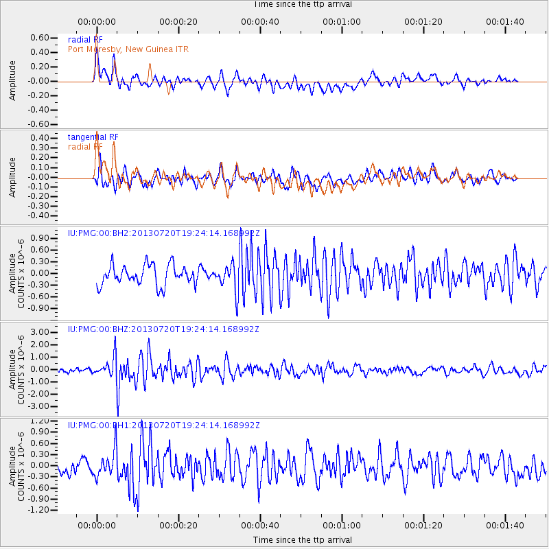
PMG Port Moresby, New Guinea - Earthquake Result Viewer
*The percent match for this event was below the threshold and hence no stack was calculated.
| Earthquake location: |
Cook Strait, New Zealand |
| Earthquake latitude/longitude: |
-41.6/174.4 |
| Earthquake time(UTC): |
2013/07/20 (201) 19:17:10 GMT |
| Earthquake Depth: |
14 km |
| Earthquake Magnitude: |
5.7 MW, 5.6 MS, 5.8 MB, 5.9 MW |
| Earthquake Catalog/Contributor: |
NEIC PDE/NEIC PDE-W |
|
| Network: |
IU Global Seismograph Network (GSN - IRIS/USGS) |
| Station: |
PMG Port Moresby, New Guinea |
| Lat/Lon: |
9.40 S/147.16 E |
| Elevation: |
90 m |
|
| Distance: |
40.1 deg |
| Az: |
315.482 deg |
| Baz: |
147.818 deg |
| Ray Param: |
$rayparam |
*The percent match for this event was below the threshold and hence was not used in the summary stack. |
|
| Radial Match: |
75.997955 % |
| Radial Bump: |
400 |
| Transverse Match: |
65.08956 % |
| Transverse Bump: |
393 |
| SOD ConfigId: |
512894 |
| Insert Time: |
2013-09-15 23:01:37.972 +0000 |
| GWidth: |
2.5 |
| Max Bumps: |
400 |
| Tol: |
0.001 |
|
Signal To Noise
| Channel | StoN | STA | LTA |
| IU:PMG:00:BHZ:20130720T19:24:14.168992Z | 3.2311175 | 8.2067436E-7 | 2.5399086E-7 |
| IU:PMG:00:BH1:20130720T19:24:14.168992Z | 1.693442 | 3.7463712E-7 | 2.212282E-7 |
| IU:PMG:00:BH2:20130720T19:24:14.168992Z | 1.4256542 | 3.5978636E-7 | 2.523658E-7 |
| Arrivals |
| Ps | |
| PpPs | |
| PsPs/PpSs | |


