You are here: Home > Network List > TA - USArray Transportable Network (new EarthScope stations) Stations List
> Station TPFO Pinon Flats, CA, USA > Earthquake Result Viewer
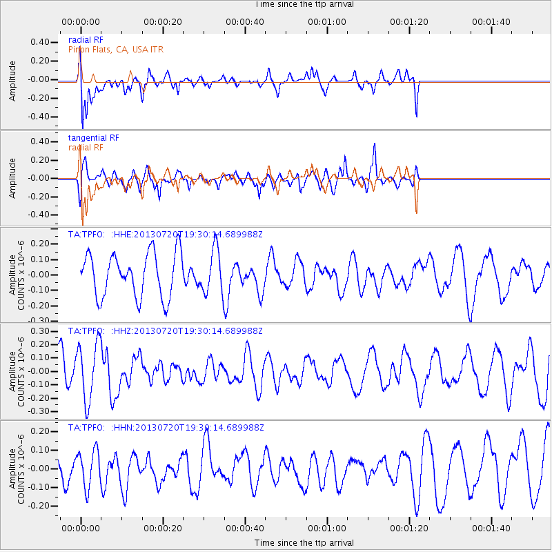
TPFO Pinon Flats, CA, USA - Earthquake Result Viewer
*The percent match for this event was below the threshold and hence no stack was calculated.
| Earthquake location: |
Cook Strait, New Zealand |
| Earthquake latitude/longitude: |
-41.6/174.4 |
| Earthquake time(UTC): |
2013/07/20 (201) 19:17:10 GMT |
| Earthquake Depth: |
14 km |
| Earthquake Magnitude: |
5.7 MW, 5.6 MS, 5.8 MB, 5.9 MW |
| Earthquake Catalog/Contributor: |
NEIC PDE/NEIC PDE-W |
|
| Network: |
TA USArray Transportable Network (new EarthScope stations) |
| Station: |
TPFO Pinon Flats, CA, USA |
| Lat/Lon: |
33.61 N/116.45 W |
| Elevation: |
1275 m |
|
| Distance: |
98.2 deg |
| Az: |
51.996 deg |
| Baz: |
225.049 deg |
| Ray Param: |
$rayparam |
*The percent match for this event was below the threshold and hence was not used in the summary stack. |
|
| Radial Match: |
81.465645 % |
| Radial Bump: |
400 |
| Transverse Match: |
69.48948 % |
| Transverse Bump: |
400 |
| SOD ConfigId: |
512894 |
| Insert Time: |
2013-09-15 23:03:02.482 +0000 |
| GWidth: |
2.5 |
| Max Bumps: |
400 |
| Tol: |
0.001 |
|
Signal To Noise
| Channel | StoN | STA | LTA |
| TA:TPFO: :HHZ:20130720T19:30:14.689988Z | 1.5952634 | 2.1866673E-7 | 1.370725E-7 |
| TA:TPFO: :HHN:20130720T19:30:14.689988Z | 1.3346392 | 9.9607114E-8 | 7.463224E-8 |
| TA:TPFO: :HHE:20130720T19:30:14.689988Z | 1.0155655 | 1.433319E-7 | 1.4113508E-7 |
| Arrivals |
| Ps | |
| PpPs | |
| PsPs/PpSs | |


