You are here: Home > Network List > UW - Pacific Northwest Regional Seismic Network Stations List
> Station TTW Tolt Res, WA CREST BB SMO > Earthquake Result Viewer
TTW Tolt Res, WA CREST BB SMO - Earthquake Result Viewer
| Earthquake location: |
Southeast Of Honshu, Japan |
| Earthquake latitude/longitude: |
29.3/139.0 |
| Earthquake time(UTC): |
2002/08/02 (214) 23:11:39 GMT |
| Earthquake Depth: |
426 km |
| Earthquake Magnitude: |
5.5 MB, 6.3 MW, 6.3 MW |
| Earthquake Catalog/Contributor: |
WHDF/NEIC |
|
| Network: |
UW Pacific Northwest Regional Seismic Network |
| Station: |
TTW Tolt Res, WA CREST BB SMO |
| Lat/Lon: |
47.69 N/121.69 W |
| Elevation: |
542 m |
|
| Distance: |
74.8 deg |
| Az: |
43.702 deg |
| Baz: |
296.684 deg |
| Ray Param: |
0.050848406 |
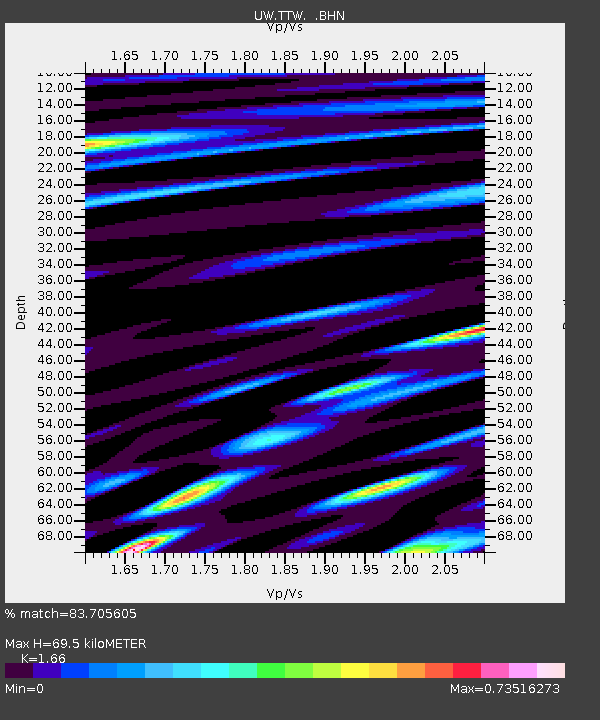
| Estimated Moho Depth: |
69.5 km |
| Estimated Crust Vp/Vs: |
1.66 |
| Assumed Crust Vp: |
6.597 km/s |
| Estimated Crust Vs: |
3.974 km/s |
| Estimated Crust Poisson's Ratio: |
0.22 |
|
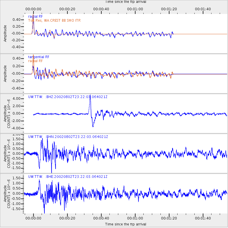
| Radial Match: |
83.705605 % |
| Radial Bump: |
400 |
| Transverse Match: |
78.42255 % |
| Transverse Bump: |
400 |
| SOD ConfigId: |
20082 |
| Insert Time: |
2010-02-27 05:07:38.801 +0000 |
| GWidth: |
2.5 |
| Max Bumps: |
400 |
| Tol: |
0.001 |
|
Signal To Noise
| Channel | StoN | STA | LTA |
| UW:TTW: :BHN:20020802T23:22:03.064021Z | 6.478207 | 6.1019426E-7 | 9.419184E-8 |
| UW:TTW: :BHE:20020802T23:22:03.064021Z | 5.282862 | 4.4850216E-7 | 8.489757E-8 |
| UW:TTW: :BHZ:20020802T23:22:03.064021Z | 17.89418 | 1.6850519E-6 | 9.4167596E-8 |
| Arrivals |
| Ps | 7.2 SECOND |
| PpPs | 27 SECOND |
| PsPs/PpSs | 34 SECOND |


