You are here: Home > Network List > IU - Global Seismograph Network (GSN - IRIS/USGS) Stations List
> Station PMG Port Moresby, New Guinea > Earthquake Result Viewer
PMG Port Moresby, New Guinea - Earthquake Result Viewer
| Earthquake location: |
Cook Strait, New Zealand |
| Earthquake latitude/longitude: |
-41.7/174.3 |
| Earthquake time(UTC): |
2013/07/21 (202) 05:09:31 GMT |
| Earthquake Depth: |
17 km |
| Earthquake Magnitude: |
6.4 MW, 6.1 MB, 6.5 MW, 6.7 MS |
| Earthquake Catalog/Contributor: |
NEIC PDE/NEIC PDE-W |
|
| Network: |
IU Global Seismograph Network (GSN - IRIS/USGS) |
| Station: |
PMG Port Moresby, New Guinea |
| Lat/Lon: |
9.40 S/147.16 E |
| Elevation: |
90 m |
|
| Distance: |
40.1 deg |
| Az: |
315.6 deg |
| Baz: |
147.93 deg |
| Ray Param: |
0.07456805 |
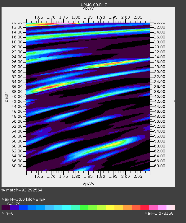
| Estimated Moho Depth: |
10.0 km |
| Estimated Crust Vp/Vs: |
1.79 |
| Assumed Crust Vp: |
6.122 km/s |
| Estimated Crust Vs: |
3.42 km/s |
| Estimated Crust Poisson's Ratio: |
0.27 |
|
| Radial Match: |
93.292564 % |
| Radial Bump: |
400 |
| Transverse Match: |
84.64954 % |
| Transverse Bump: |
400 |
| SOD ConfigId: |
512894 |
| Insert Time: |
2013-09-15 23:09:58.423 +0000 |
| GWidth: |
2.5 |
| Max Bumps: |
400 |
| Tol: |
0.001 |
|
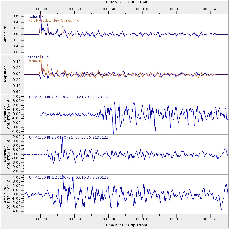
Signal To Noise
| Channel | StoN | STA | LTA |
| IU:PMG:00:BHZ:20130721T05:16:35.219012Z | 4.6738853 | 9.87702E-7 | 2.1132354E-7 |
| IU:PMG:00:BH1:20130721T05:16:35.219012Z | 1.9645284 | 4.3558217E-7 | 2.2172352E-7 |
| IU:PMG:00:BH2:20130721T05:16:35.219012Z | 1.5955793 | 2.9202582E-7 | 1.8302183E-7 |
| Arrivals |
| Ps | 1.4 SECOND |
| PpPs | 4.3 SECOND |
| PsPs/PpSs | 5.7 SECOND |


