You are here: Home > Network List > AK - Alaska Regional Network Stations List
> Station CHI Chirikof Island > Earthquake Result Viewer
CHI Chirikof Island - Earthquake Result Viewer
| Earthquake location: |
Gansu, China |
| Earthquake latitude/longitude: |
34.5/104.3 |
| Earthquake time(UTC): |
2013/07/21 (202) 23:45:56 GMT |
| Earthquake Depth: |
8.0 km |
| Earthquake Magnitude: |
5.9 MW, 5.9 MW, 6.1 MB, 6.2 MS |
| Earthquake Catalog/Contributor: |
NEIC PDE/NEIC PDE-W |
|
| Network: |
AK Alaska Regional Network |
| Station: |
CHI Chirikof Island |
| Lat/Lon: |
55.82 N/155.62 W |
| Elevation: |
234 m |
|
| Distance: |
67.4 deg |
| Az: |
36.986 deg |
| Baz: |
298.317 deg |
| Ray Param: |
0.05696272 |
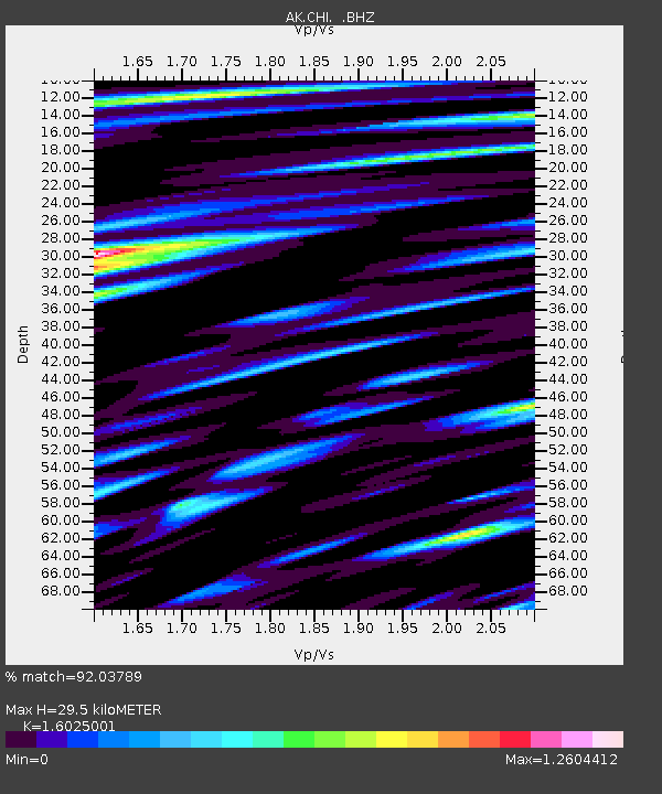
| Estimated Moho Depth: |
29.5 km |
| Estimated Crust Vp/Vs: |
1.60 |
| Assumed Crust Vp: |
3.999 km/s |
| Estimated Crust Vs: |
2.495 km/s |
| Estimated Crust Poisson's Ratio: |
0.18 |
|
| Radial Match: |
92.03789 % |
| Radial Bump: |
400 |
| Transverse Match: |
80.03288 % |
| Transverse Bump: |
400 |
| SOD ConfigId: |
512894 |
| Insert Time: |
2013-09-15 23:13:24.711 +0000 |
| GWidth: |
2.5 |
| Max Bumps: |
400 |
| Tol: |
0.001 |
|

Signal To Noise
| Channel | StoN | STA | LTA |
| AK:CHI: :BHZ:20130721T23:56:21.467983Z | 1.5398928 | 2.8644051E-6 | 1.8601329E-6 |
| AK:CHI: :BHN:20130721T23:56:21.467983Z | 1.5105234 | 1.2311361E-6 | 8.1503947E-7 |
| AK:CHI: :BHE:20130721T23:56:21.467983Z | 1.560719 | 3.952312E-6 | 2.5323661E-6 |
| Arrivals |
| Ps | 4.5 SECOND |
| PpPs | 19 SECOND |
| PsPs/PpSs | 23 SECOND |


