You are here: Home > Network List > UW - Pacific Northwest Regional Seismic Network Stations List
> Station TTW Tolt Res, WA CREST BB SMO > Earthquake Result Viewer
TTW Tolt Res, WA CREST BB SMO - Earthquake Result Viewer
| Earthquake location: |
Strait Of Gibraltar |
| Earthquake latitude/longitude: |
35.1/-4.0 |
| Earthquake time(UTC): |
2004/02/24 (055) 02:27:46 GMT |
| Earthquake Depth: |
0.0 km |
| Earthquake Magnitude: |
6.2 MB, 6.4 MS, 6.4 MW, 6.4 MW |
| Earthquake Catalog/Contributor: |
WHDF/NEIC |
|
| Network: |
UW Pacific Northwest Regional Seismic Network |
| Station: |
TTW Tolt Res, WA CREST BB SMO |
| Lat/Lon: |
47.69 N/121.69 W |
| Elevation: |
542 m |
|
| Distance: |
80.5 deg |
| Az: |
322.663 deg |
| Baz: |
47.373 deg |
| Ray Param: |
0.048258293 |
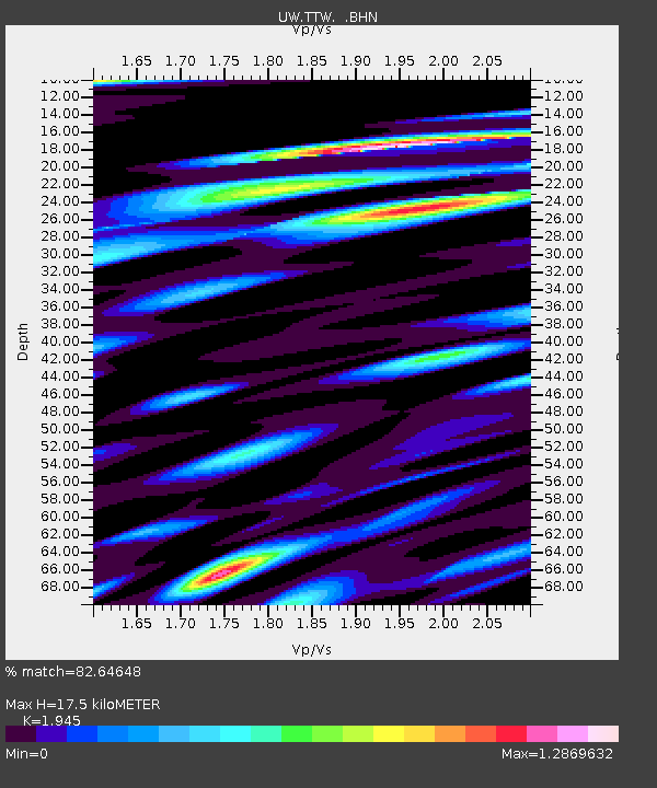
| Estimated Moho Depth: |
17.5 km |
| Estimated Crust Vp/Vs: |
1.95 |
| Assumed Crust Vp: |
6.597 km/s |
| Estimated Crust Vs: |
3.392 km/s |
| Estimated Crust Poisson's Ratio: |
0.32 |
|
| Radial Match: |
82.64648 % |
| Radial Bump: |
400 |
| Transverse Match: |
79.51575 % |
| Transverse Bump: |
400 |
| SOD ConfigId: |
2459 |
| Insert Time: |
2010-02-27 05:08:20.907 +0000 |
| GWidth: |
2.5 |
| Max Bumps: |
400 |
| Tol: |
0.001 |
|

Signal To Noise
| Channel | StoN | STA | LTA |
| UW:TTW: :BHN:20040224T02:39:28.545002Z | 4.8007207 | 510.7315 | 106.38642 |
| UW:TTW: :BHE:20040224T02:39:28.545002Z | 4.138692 | 389.93915 | 94.21797 |
| UW:TTW: :BHZ:20040224T02:39:28.545002Z | 9.086828 | 1451.2454 | 159.70868 |
| Arrivals |
| Ps | 2.6 SECOND |
| PpPs | 7.6 SECOND |
| PsPs/PpSs | 10 SECOND |


