You are here: Home > Network List > UW - Pacific Northwest Regional Seismic Network Stations List
> Station TTW Tolt Res, WA CREST BB SMO > Earthquake Result Viewer
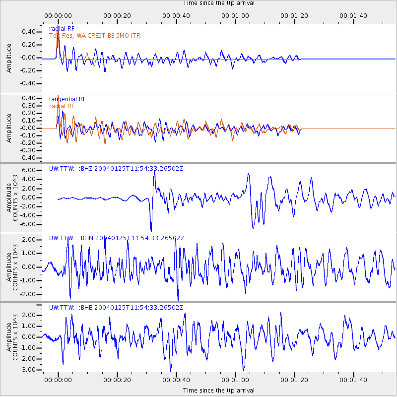
TTW Tolt Res, WA CREST BB SMO - Earthquake Result Viewer

| Earthquake location: |
Tonga Islands |
| Earthquake latitude/longitude: |
-16.8/-174.2 |
| Earthquake time(UTC): |
2004/01/25 (025) 11:43:11 GMT |
| Earthquake Depth: |
130 km |
| Earthquake Magnitude: |
6.4 MB, 6.7 MW, 6.7 MW |
| Earthquake Catalog/Contributor: |
WHDF/NEIC |
|
| Network: |
UW Pacific Northwest Regional Seismic Network |
| Station: |
TTW Tolt Res, WA CREST BB SMO |
| Lat/Lon: |
47.69 N/121.69 W |
| Elevation: |
542 m |
|
| Distance: |
79.5 deg |
| Az: |
33.029 deg |
| Baz: |
230.599 deg |
| Ray Param: |
0.04858957 |
| Estimated Moho Depth: |
33.5 km |
| Estimated Crust Vp/Vs: |
2.02 |
| Assumed Crust Vp: |
6.597 km/s |
| Estimated Crust Vs: |
3.266 km/s |
| Estimated Crust Poisson's Ratio: |
0.34 |
|
| Radial Match: |
89.0849 % |
| Radial Bump: |
400 |
| Transverse Match: |
84.14129 % |
| Transverse Bump: |
400 |
| SOD ConfigId: |
2459 |
| Insert Time: |
2010-02-27 05:08:22.391 +0000 |
| GWidth: |
2.5 |
| Max Bumps: |
400 |
| Tol: |
0.001 |
|
Signal To Noise
| Channel | StoN | STA | LTA |
| UW:TTW: :BHN:20040125T11:54:33.26502Z | 4.734649 | 935.73254 | 197.63503 |
| UW:TTW: :BHE:20040125T11:54:33.26502Z | 5.4079633 | 1053.539 | 194.81253 |
| UW:TTW: :BHZ:20040125T11:54:33.26502Z | 14.889234 | 3000.8232 | 201.54318 |
| Arrivals |
| Ps | 5.3 SECOND |
| PpPs | 15 SECOND |
| PsPs/PpSs | 20 SECOND |


