You are here: Home > Network List > UW - Pacific Northwest Regional Seismic Network Stations List
> Station TTW Tolt Res, WA CREST BB SMO > Earthquake Result Viewer
TTW Tolt Res, WA CREST BB SMO - Earthquake Result Viewer

| Earthquake location: |
Near East Coast Of Kamchatka |
| Earthquake latitude/longitude: |
55.2/162.7 |
| Earthquake time(UTC): |
2004/04/14 (105) 01:54:09 GMT |
| Earthquake Depth: |
51 km |
| Earthquake Magnitude: |
6.0 MB, 6.2 MW, 6.1 MW |
| Earthquake Catalog/Contributor: |
WHDF/NEIC |
|
| Network: |
UW Pacific Northwest Regional Seismic Network |
| Station: |
TTW Tolt Res, WA CREST BB SMO |
| Lat/Lon: |
47.69 N/121.69 W |
| Elevation: |
542 m |
|
| Distance: |
45.6 deg |
| Az: |
66.453 deg |
| Baz: |
308.971 deg |
| Ray Param: |
0.07105828 |
| Estimated Moho Depth: |
37.0 km |
| Estimated Crust Vp/Vs: |
2.01 |
| Assumed Crust Vp: |
6.597 km/s |
| Estimated Crust Vs: |
3.282 km/s |
| Estimated Crust Poisson's Ratio: |
0.34 |
|
| Radial Match: |
80.70397 % |
| Radial Bump: |
400 |
| Transverse Match: |
66.991234 % |
| Transverse Bump: |
400 |
| SOD ConfigId: |
2459 |
| Insert Time: |
2010-02-27 05:08:23.833 +0000 |
| GWidth: |
2.5 |
| Max Bumps: |
400 |
| Tol: |
0.001 |
|
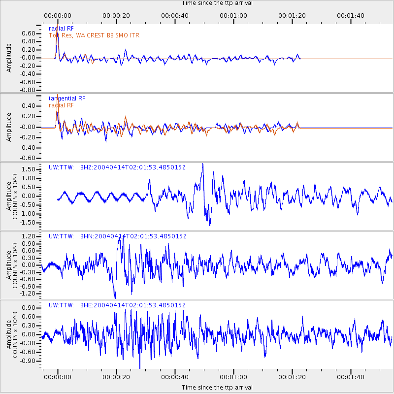
Signal To Noise
| Channel | StoN | STA | LTA |
| UW:TTW: :BHN:20040414T02:01:53.485015Z | 1.4769412 | 186.40852 | 126.212555 |
| UW:TTW: :BHE:20040414T02:01:53.485015Z | 1.1219394 | 162.18304 | 144.55597 |
| UW:TTW: :BHZ:20040414T02:01:53.485015Z | 2.4386284 | 412.04672 | 168.9666 |
| Arrivals |
| Ps | 6.0 SECOND |
| PpPs | 16 SECOND |
| PsPs/PpSs | 22 SECOND |


