You are here: Home > Network List > TA - USArray Transportable Network (new EarthScope stations) Stations List
> Station MSTX Muleshoe, TX, USA > Earthquake Result Viewer
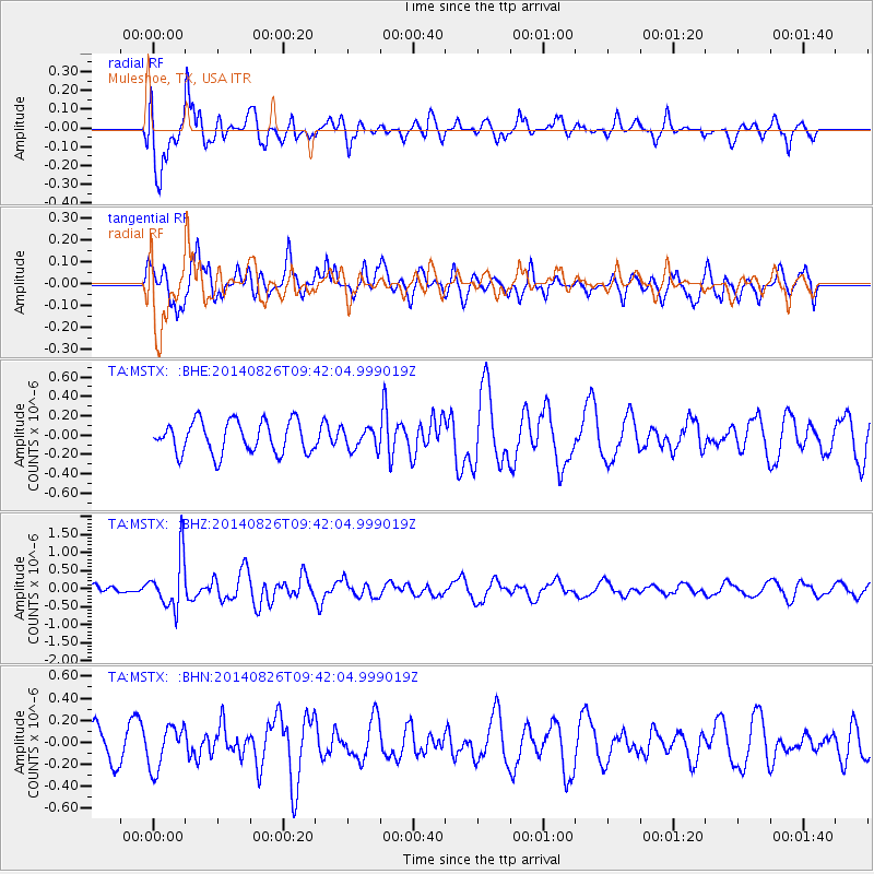
MSTX Muleshoe, TX, USA - Earthquake Result Viewer
*The percent match for this event was below the threshold and hence no stack was calculated.
| Earthquake location: |
Tonga Islands |
| Earthquake latitude/longitude: |
-15.2/-173.2 |
| Earthquake time(UTC): |
2014/08/26 (238) 09:30:12 GMT |
| Earthquake Depth: |
10 km |
| Earthquake Magnitude: |
5.6 MB |
| Earthquake Catalog/Contributor: |
NEIC PDE/NEIC COMCAT |
|
| Network: |
TA USArray Transportable Network (new EarthScope stations) |
| Station: |
MSTX Muleshoe, TX, USA |
| Lat/Lon: |
33.97 N/102.77 W |
| Elevation: |
1167 m |
|
| Distance: |
82.9 deg |
| Az: |
52.084 deg |
| Baz: |
246.398 deg |
| Ray Param: |
$rayparam |
*The percent match for this event was below the threshold and hence was not used in the summary stack. |
|
| Radial Match: |
70.51092 % |
| Radial Bump: |
400 |
| Transverse Match: |
68.33448 % |
| Transverse Bump: |
400 |
| SOD ConfigId: |
3390531 |
| Insert Time: |
2019-04-13 15:13:33.292 +0000 |
| GWidth: |
2.5 |
| Max Bumps: |
400 |
| Tol: |
0.001 |
|
Signal To Noise
| Channel | StoN | STA | LTA |
| TA:MSTX: :BHZ:20140826T09:42:04.999019Z | 3.5902803 | 7.063679E-7 | 1.9674451E-7 |
| TA:MSTX: :BHN:20140826T09:42:04.999019Z | 0.9622066 | 1.9389616E-7 | 2.0151198E-7 |
| TA:MSTX: :BHE:20140826T09:42:04.999019Z | 1.0707077 | 1.7677657E-7 | 1.6510255E-7 |
| Arrivals |
| Ps | |
| PpPs | |
| PsPs/PpSs | |


