You are here: Home > Network List > GE - GEOFON Stations List
> Station SUMG GEOFON Station Summit Camp, Greenland > Earthquake Result Viewer
SUMG GEOFON Station Summit Camp, Greenland - Earthquake Result Viewer
| Earthquake location: |
Gansu, China |
| Earthquake latitude/longitude: |
34.5/104.3 |
| Earthquake time(UTC): |
2013/07/21 (202) 23:45:56 GMT |
| Earthquake Depth: |
8.0 km |
| Earthquake Magnitude: |
5.9 MW, 5.9 MW, 6.1 MB, 6.2 MS |
| Earthquake Catalog/Contributor: |
NEIC PDE/NEIC PDE-W |
|
| Network: |
GE GEOFON |
| Station: |
SUMG GEOFON Station Summit Camp, Greenland |
| Lat/Lon: |
72.58 N/38.45 W |
| Elevation: |
3240 m |
|
| Distance: |
70.1 deg |
| Az: |
348.811 deg |
| Baz: |
32.133 deg |
| Ray Param: |
0.05518974 |
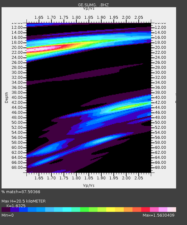
| Estimated Moho Depth: |
20.5 km |
| Estimated Crust Vp/Vs: |
1.63 |
| Assumed Crust Vp: |
6.261 km/s |
| Estimated Crust Vs: |
3.835 km/s |
| Estimated Crust Poisson's Ratio: |
0.20 |
|
| Radial Match: |
87.59366 % |
| Radial Bump: |
400 |
| Transverse Match: |
78.95082 % |
| Transverse Bump: |
400 |
| SOD ConfigId: |
512894 |
| Insert Time: |
2013-09-15 23:26:41.919 +0000 |
| GWidth: |
2.5 |
| Max Bumps: |
400 |
| Tol: |
0.001 |
|

Signal To Noise
| Channel | StoN | STA | LTA |
| GE:SUMG: :BHZ:20130721T23:56:38.245022Z | 16.298689 | 4.7121216E-6 | 2.8911046E-7 |
| GE:SUMG: :BHN:20130721T23:56:38.245022Z | 2.2679436 | 7.7966564E-7 | 3.437765E-7 |
| GE:SUMG: :BHE:20130721T23:56:38.245022Z | 1.8412521 | 2.952942E-7 | 1.6037684E-7 |
| Arrivals |
| Ps | 2.2 SECOND |
| PpPs | 8.3 SECOND |
| PsPs/PpSs | 10 SECOND |


