You are here: Home > Network List > UW - Pacific Northwest Regional Seismic Network Stations List
> Station TTW Tolt Res, WA CREST BB SMO > Earthquake Result Viewer
TTW Tolt Res, WA CREST BB SMO - Earthquake Result Viewer
| Earthquake location: |
Guerrero, Mexico |
| Earthquake latitude/longitude: |
18.7/-101.6 |
| Earthquake time(UTC): |
1997/05/22 (142) 07:50:53 GMT |
| Earthquake Depth: |
70 km |
| Earthquake Magnitude: |
5.9 MB, 6.0 MS, 6.6 UNKNOWN, 6.5 MW |
| Earthquake Catalog/Contributor: |
WHDF/NEIC |
|
| Network: |
UW Pacific Northwest Regional Seismic Network |
| Station: |
TTW Tolt Res, WA CREST BB SMO |
| Lat/Lon: |
47.69 N/121.69 W |
| Elevation: |
542 m |
|
| Distance: |
33.3 deg |
| Az: |
334.973 deg |
| Baz: |
143.586 deg |
| Ray Param: |
0.07811316 |
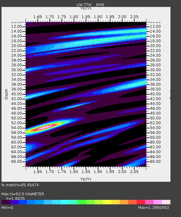
| Estimated Moho Depth: |
53.5 km |
| Estimated Crust Vp/Vs: |
1.68 |
| Assumed Crust Vp: |
6.597 km/s |
| Estimated Crust Vs: |
3.921 km/s |
| Estimated Crust Poisson's Ratio: |
0.23 |
|
| Radial Match: |
85.45474 % |
| Radial Bump: |
290 |
| Transverse Match: |
63.23745 % |
| Transverse Bump: |
400 |
| SOD ConfigId: |
6273 |
| Insert Time: |
2010-02-27 05:08:51.016 +0000 |
| GWidth: |
2.5 |
| Max Bumps: |
400 |
| Tol: |
0.001 |
|

Signal To Noise
| Channel | StoN | STA | LTA |
| UW:TTW: :BHN:19970522T07:56:53.838013Z | 23.154808 | 1196.2736 | 51.664154 |
| UW:TTW: :BHE:19970522T07:56:53.838013Z | 9.913908 | 803.0787 | 81.00526 |
| UW:TTW: :BHZ:19970522T07:56:53.838013Z | 41.119884 | 2458.8242 | 59.796474 |
| Arrivals |
| Ps | 6.0 SECOND |
| PpPs | 20 SECOND |
| PsPs/PpSs | 26 SECOND |


