You are here: Home > Network List > II - Global Seismograph Network (GSN - IRIS/IDA) Stations List
> Station ABPO Ambohimpanompo, Madagascar > Earthquake Result Viewer
ABPO Ambohimpanompo, Madagascar - Earthquake Result Viewer
| Earthquake location: |
Gansu, China |
| Earthquake latitude/longitude: |
34.5/104.3 |
| Earthquake time(UTC): |
2013/07/21 (202) 23:45:56 GMT |
| Earthquake Depth: |
8.0 km |
| Earthquake Magnitude: |
5.9 MW, 5.9 MW, 6.1 MB, 6.2 MS |
| Earthquake Catalog/Contributor: |
NEIC PDE/NEIC PDE-W |
|
| Network: |
II Global Seismograph Network (GSN - IRIS/IDA) |
| Station: |
ABPO Ambohimpanompo, Madagascar |
| Lat/Lon: |
19.02 S/47.23 E |
| Elevation: |
1528 m |
|
| Distance: |
76.0 deg |
| Az: |
234.901 deg |
| Baz: |
45.571 deg |
| Ray Param: |
0.051313784 |
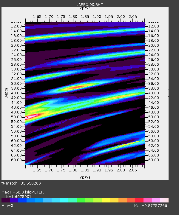
| Estimated Moho Depth: |
50.0 km |
| Estimated Crust Vp/Vs: |
1.61 |
| Assumed Crust Vp: |
6.642 km/s |
| Estimated Crust Vs: |
4.132 km/s |
| Estimated Crust Poisson's Ratio: |
0.18 |
|
| Radial Match: |
83.556206 % |
| Radial Bump: |
381 |
| Transverse Match: |
68.93168 % |
| Transverse Bump: |
400 |
| SOD ConfigId: |
512894 |
| Insert Time: |
2013-09-15 23:28:57.621 +0000 |
| GWidth: |
2.5 |
| Max Bumps: |
400 |
| Tol: |
0.001 |
|

Signal To Noise
| Channel | StoN | STA | LTA |
| II:ABPO:00:BHZ:20130721T23:57:12.719021Z | 6.90922 | 1.6340626E-6 | 2.3650463E-7 |
| II:ABPO:00:BH1:20130721T23:57:12.719021Z | 2.8863177 | 3.4445782E-7 | 1.193416E-7 |
| II:ABPO:00:BH2:20130721T23:57:12.719021Z | 5.5042777 | 7.030559E-7 | 1.27729E-7 |
| Arrivals |
| Ps | 4.7 SECOND |
| PpPs | 19 SECOND |
| PsPs/PpSs | 24 SECOND |


