You are here: Home > Network List > UW - Pacific Northwest Regional Seismic Network Stations List
> Station TTW Tolt Res, WA CREST BB SMO > Earthquake Result Viewer
TTW Tolt Res, WA CREST BB SMO - Earthquake Result Viewer
| Earthquake location: |
Northern Peru |
| Earthquake latitude/longitude: |
-4.4/-76.7 |
| Earthquake time(UTC): |
1997/10/28 (301) 06:15:17 GMT |
| Earthquake Depth: |
112 km |
| Earthquake Magnitude: |
6.6 MB, 6.3 MS, 7.2 UNKNOWN, 6.6 ME |
| Earthquake Catalog/Contributor: |
WHDF/NEIC |
|
| Network: |
UW Pacific Northwest Regional Seismic Network |
| Station: |
TTW Tolt Res, WA CREST BB SMO |
| Lat/Lon: |
47.69 N/121.69 W |
| Elevation: |
542 m |
|
| Distance: |
65.1 deg |
| Az: |
328.227 deg |
| Baz: |
128.993 deg |
| Ray Param: |
0.058165357 |
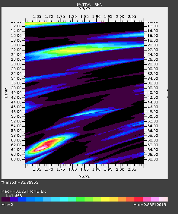
| Estimated Moho Depth: |
63.25 km |
| Estimated Crust Vp/Vs: |
1.66 |
| Assumed Crust Vp: |
6.597 km/s |
| Estimated Crust Vs: |
3.962 km/s |
| Estimated Crust Poisson's Ratio: |
0.22 |
|
| Radial Match: |
83.36355 % |
| Radial Bump: |
400 |
| Transverse Match: |
83.26437 % |
| Transverse Bump: |
400 |
| SOD ConfigId: |
6273 |
| Insert Time: |
2010-02-27 05:08:56.940 +0000 |
| GWidth: |
2.5 |
| Max Bumps: |
400 |
| Tol: |
0.001 |
|

Signal To Noise
| Channel | StoN | STA | LTA |
| UW:TTW: :BHN:19971028T06:25:15.466016Z | 1.1014371 | 15.284804 | 13.877148 |
| UW:TTW: :BHE:19971028T06:25:15.466016Z | 2.826114 | 518.13763 | 183.33925 |
| UW:TTW: :BHZ:19971028T06:25:15.466016Z | 16.23846 | 1857.4829 | 114.38786 |
| Arrivals |
| Ps | 6.7 SECOND |
| PpPs | 24 SECOND |
| PsPs/PpSs | 31 SECOND |


