You are here: Home > Network List > UW - Pacific Northwest Regional Seismic Network Stations List
> Station TTW Tolt Res, WA CREST BB SMO > Earthquake Result Viewer
TTW Tolt Res, WA CREST BB SMO - Earthquake Result Viewer

| Earthquake location: |
Vanuatu Islands |
| Earthquake latitude/longitude: |
-13.6/166.9 |
| Earthquake time(UTC): |
1998/07/25 (206) 02:39:23 GMT |
| Earthquake Depth: |
44 km |
| Earthquake Magnitude: |
5.9 MB, 6.0 MS, 6.3 UNKNOWN, 6.2 MW |
| Earthquake Catalog/Contributor: |
WHDF/NEIC |
|
| Network: |
UW Pacific Northwest Regional Seismic Network |
| Station: |
TTW Tolt Res, WA CREST BB SMO |
| Lat/Lon: |
47.69 N/121.69 W |
| Elevation: |
542 m |
|
| Distance: |
87.9 deg |
| Az: |
39.856 deg |
| Baz: |
247.274 deg |
| Ray Param: |
0.0429176 |
| Estimated Moho Depth: |
65.0 km |
| Estimated Crust Vp/Vs: |
1.80 |
| Assumed Crust Vp: |
6.597 km/s |
| Estimated Crust Vs: |
3.67 km/s |
| Estimated Crust Poisson's Ratio: |
0.28 |
|
| Radial Match: |
85.17452 % |
| Radial Bump: |
400 |
| Transverse Match: |
77.51498 % |
| Transverse Bump: |
400 |
| SOD ConfigId: |
9875 |
| Insert Time: |
2010-02-27 05:09:01.564 +0000 |
| GWidth: |
2.5 |
| Max Bumps: |
400 |
| Tol: |
0.001 |
|
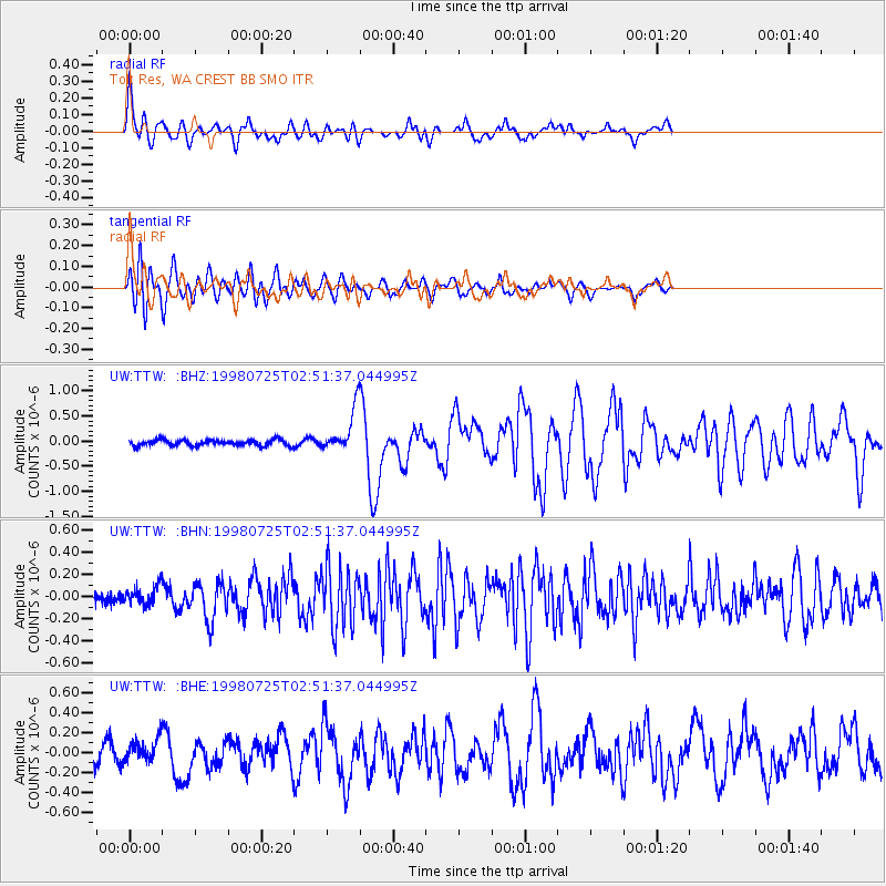
Signal To Noise
| Channel | StoN | STA | LTA |
| UW:TTW: :BHN:19980725T02:51:37.044995Z | 1.1306722 | 8.1509135E-8 | 7.2089094E-8 |
| UW:TTW: :BHE:19980725T02:51:37.044995Z | 1.5789454 | 1.09418124E-7 | 6.929823E-8 |
| UW:TTW: :BHZ:19980725T02:51:37.044995Z | 7.1749873 | 4.1701992E-7 | 5.8121348E-8 |
| Arrivals |
| Ps | 8.0 SECOND |
| PpPs | 27 SECOND |
| PsPs/PpSs | 35 SECOND |


