You are here: Home > Network List > TA - USArray Transportable Network (new EarthScope stations) Stations List
> Station MDND Maddock, ND, USA > Earthquake Result Viewer
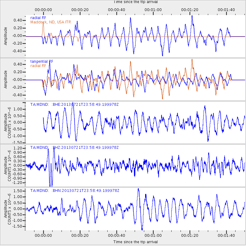
MDND Maddock, ND, USA - Earthquake Result Viewer
*The percent match for this event was below the threshold and hence no stack was calculated.
| Earthquake location: |
Gansu, China |
| Earthquake latitude/longitude: |
34.5/104.3 |
| Earthquake time(UTC): |
2013/07/21 (202) 23:45:56 GMT |
| Earthquake Depth: |
8.0 km |
| Earthquake Magnitude: |
5.9 MW, 5.9 MW, 6.1 MB, 6.2 MS |
| Earthquake Catalog/Contributor: |
NEIC PDE/NEIC PDE-W |
|
| Network: |
TA USArray Transportable Network (new EarthScope stations) |
| Station: |
MDND Maddock, ND, USA |
| Lat/Lon: |
47.85 N/99.60 W |
| Elevation: |
479 m |
|
| Distance: |
95.3 deg |
| Az: |
15.883 deg |
| Baz: |
340.396 deg |
| Ray Param: |
$rayparam |
*The percent match for this event was below the threshold and hence was not used in the summary stack. |
|
| Radial Match: |
61.608173 % |
| Radial Bump: |
349 |
| Transverse Match: |
56.842175 % |
| Transverse Bump: |
400 |
| SOD ConfigId: |
512894 |
| Insert Time: |
2013-09-15 23:39:49.580 +0000 |
| GWidth: |
2.5 |
| Max Bumps: |
400 |
| Tol: |
0.001 |
|
Signal To Noise
| Channel | StoN | STA | LTA |
| TA:MDND: :BHZ:20130721T23:58:49.199978Z | 4.080952 | 6.6712516E-7 | 1.6347293E-7 |
| TA:MDND: :BHN:20130721T23:58:49.199978Z | 0.3687392 | 1.9930232E-7 | 5.404967E-7 |
| TA:MDND: :BHE:20130721T23:58:49.199978Z | 0.7014075 | 4.6068592E-7 | 6.5680206E-7 |
| Arrivals |
| Ps | |
| PpPs | |
| PsPs/PpSs | |


