You are here: Home > Network List > US - United States National Seismic Network Stations List
> Station LAO LASA Array, Montana, USA > Earthquake Result Viewer
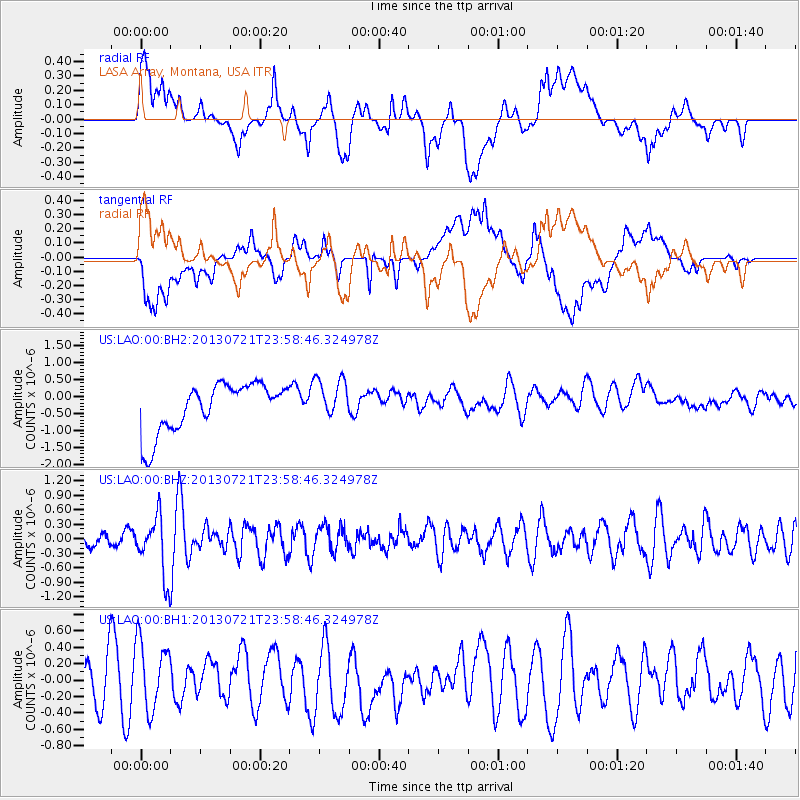
LAO LASA Array, Montana, USA - Earthquake Result Viewer
*The percent match for this event was below the threshold and hence no stack was calculated.
| Earthquake location: |
Gansu, China |
| Earthquake latitude/longitude: |
34.5/104.3 |
| Earthquake time(UTC): |
2013/07/21 (202) 23:45:56 GMT |
| Earthquake Depth: |
8.0 km |
| Earthquake Magnitude: |
5.9 MW, 5.9 MW, 6.1 MB, 6.2 MS |
| Earthquake Catalog/Contributor: |
NEIC PDE/NEIC PDE-W |
|
| Network: |
US United States National Seismic Network |
| Station: |
LAO LASA Array, Montana, USA |
| Lat/Lon: |
46.69 N/106.22 W |
| Elevation: |
902 m |
|
| Distance: |
94.6 deg |
| Az: |
20.511 deg |
| Baz: |
335.146 deg |
| Ray Param: |
$rayparam |
*The percent match for this event was below the threshold and hence was not used in the summary stack. |
|
| Radial Match: |
46.21216 % |
| Radial Bump: |
400 |
| Transverse Match: |
29.46832 % |
| Transverse Bump: |
400 |
| SOD ConfigId: |
512894 |
| Insert Time: |
2013-09-15 23:41:03.596 +0000 |
| GWidth: |
2.5 |
| Max Bumps: |
400 |
| Tol: |
0.001 |
|
Signal To Noise
| Channel | StoN | STA | LTA |
| US:LAO:00:BHZ:20130721T23:58:46.324978Z | 3.305114 | 6.100382E-7 | 1.8457402E-7 |
| US:LAO:00:BH1:20130721T23:58:46.324978Z | 1.6844085 | 4.5243908E-7 | 2.686041E-7 |
| US:LAO:00:BH2:20130721T23:58:46.324978Z | 0.8441364 | 6.093995E-7 | 7.219206E-7 |
| Arrivals |
| Ps | |
| PpPs | |
| PsPs/PpSs | |


