You are here: Home > Network List > US - United States National Seismic Network Stations List
> Station MSO Missoula, Montana, USA > Earthquake Result Viewer
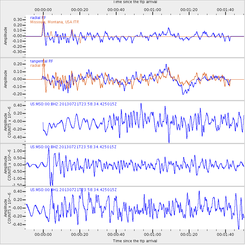
MSO Missoula, Montana, USA - Earthquake Result Viewer
*The percent match for this event was below the threshold and hence no stack was calculated.
| Earthquake location: |
Gansu, China |
| Earthquake latitude/longitude: |
34.5/104.3 |
| Earthquake time(UTC): |
2013/07/21 (202) 23:45:56 GMT |
| Earthquake Depth: |
8.0 km |
| Earthquake Magnitude: |
5.9 MW, 5.9 MW, 6.1 MB, 6.2 MS |
| Earthquake Catalog/Contributor: |
NEIC PDE/NEIC PDE-W |
|
| Network: |
US United States National Seismic Network |
| Station: |
MSO Missoula, Montana, USA |
| Lat/Lon: |
46.83 N/113.94 W |
| Elevation: |
1264 m |
|
| Distance: |
92.0 deg |
| Az: |
25.144 deg |
| Baz: |
329.268 deg |
| Ray Param: |
$rayparam |
*The percent match for this event was below the threshold and hence was not used in the summary stack. |
|
| Radial Match: |
64.049805 % |
| Radial Bump: |
400 |
| Transverse Match: |
31.858942 % |
| Transverse Bump: |
400 |
| SOD ConfigId: |
512894 |
| Insert Time: |
2013-09-15 23:41:10.806 +0000 |
| GWidth: |
2.5 |
| Max Bumps: |
400 |
| Tol: |
0.001 |
|
Signal To Noise
| Channel | StoN | STA | LTA |
| US:MSO:00:BHZ:20130721T23:58:34.425015Z | 8.1511 | 6.346398E-7 | 7.7859404E-8 |
| US:MSO:00:BH1:20130721T23:58:34.425015Z | 2.1579976 | 2.0844787E-7 | 9.659318E-8 |
| US:MSO:00:BH2:20130721T23:58:34.425015Z | 0.79919326 | 9.252885E-8 | 1.15777816E-7 |
| Arrivals |
| Ps | |
| PpPs | |
| PsPs/PpSs | |


