You are here: Home > Network List > UW - Pacific Northwest Regional Seismic Network Stations List
> Station UMAT Pilot Rock, OR, USA > Earthquake Result Viewer
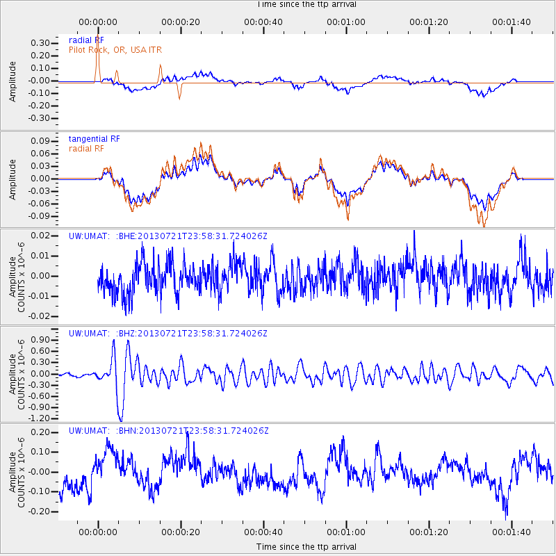
UMAT Pilot Rock, OR, USA - Earthquake Result Viewer
*The percent match for this event was below the threshold and hence no stack was calculated.
| Earthquake location: |
Gansu, China |
| Earthquake latitude/longitude: |
34.5/104.3 |
| Earthquake time(UTC): |
2013/07/21 (202) 23:45:56 GMT |
| Earthquake Depth: |
8.0 km |
| Earthquake Magnitude: |
5.9 MW, 5.9 MW, 6.1 MB, 6.2 MS |
| Earthquake Catalog/Contributor: |
NEIC PDE/NEIC PDE-W |
|
| Network: |
UW Pacific Northwest Regional Seismic Network |
| Station: |
UMAT Pilot Rock, OR, USA |
| Lat/Lon: |
45.29 N/118.96 W |
| Elevation: |
1318 m |
|
| Distance: |
91.4 deg |
| Az: |
28.919 deg |
| Baz: |
325.55 deg |
| Ray Param: |
$rayparam |
*The percent match for this event was below the threshold and hence was not used in the summary stack. |
|
| Radial Match: |
43.13479 % |
| Radial Bump: |
400 |
| Transverse Match: |
44.00078 % |
| Transverse Bump: |
400 |
| SOD ConfigId: |
512894 |
| Insert Time: |
2013-09-15 23:43:21.897 +0000 |
| GWidth: |
2.5 |
| Max Bumps: |
400 |
| Tol: |
0.001 |
|
Signal To Noise
| Channel | StoN | STA | LTA |
| UW:UMAT: :BHZ:20130721T23:58:31.724026Z | 7.181131 | 3.82675E-7 | 5.3288964E-8 |
| UW:UMAT: :BHN:20130721T23:58:31.724026Z | 1.2605711 | 1.0589431E-7 | 8.400503E-8 |
| UW:UMAT: :BHE:20130721T23:58:31.724026Z | 1.1077969 | 7.9236555E-9 | 7.1526243E-9 |
| Arrivals |
| Ps | |
| PpPs | |
| PsPs/PpSs | |


