You are here: Home > Network List > TA - USArray Transportable Network (new EarthScope stations) Stations List
> Station H17A Grant Village (NPS), Yellowstone Nt. Park, WY, USA > Earthquake Result Viewer
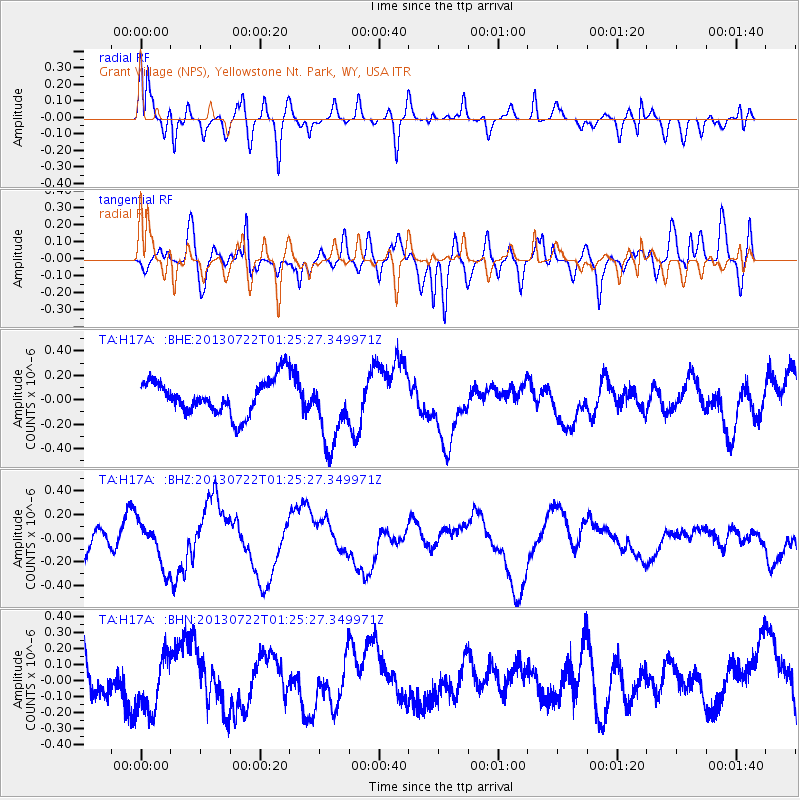
H17A Grant Village (NPS), Yellowstone Nt. Park, WY, USA - Earthquake Result Viewer
*The percent match for this event was below the threshold and hence no stack was calculated.
| Earthquake location: |
Gansu, China |
| Earthquake latitude/longitude: |
34.5/104.2 |
| Earthquake time(UTC): |
2013/07/22 (203) 01:12:34 GMT |
| Earthquake Depth: |
10 km |
| Earthquake Magnitude: |
5.6 MB |
| Earthquake Catalog/Contributor: |
NEIC PDE/NEIC PDE-W |
|
| Network: |
TA USArray Transportable Network (new EarthScope stations) |
| Station: |
H17A Grant Village (NPS), Yellowstone Nt. Park, WY, USA |
| Lat/Lon: |
44.40 N/110.58 W |
| Elevation: |
2400 m |
|
| Distance: |
95.3 deg |
| Az: |
24.231 deg |
| Baz: |
331.793 deg |
| Ray Param: |
$rayparam |
*The percent match for this event was below the threshold and hence was not used in the summary stack. |
|
| Radial Match: |
78.12252 % |
| Radial Bump: |
400 |
| Transverse Match: |
50.48096 % |
| Transverse Bump: |
400 |
| SOD ConfigId: |
512894 |
| Insert Time: |
2013-09-16 00:02:08.570 +0000 |
| GWidth: |
2.5 |
| Max Bumps: |
400 |
| Tol: |
0.001 |
|
Signal To Noise
| Channel | StoN | STA | LTA |
| TA:H17A: :BHZ:20130722T01:25:27.349971Z | 1.5540624 | 1.8461937E-7 | 1.18797914E-7 |
| TA:H17A: :BHN:20130722T01:25:27.349971Z | 1.206434 | 1.7498628E-7 | 1.4504423E-7 |
| TA:H17A: :BHE:20130722T01:25:27.349971Z | 2.0903568 | 2.9949126E-7 | 1.432728E-7 |
| Arrivals |
| Ps | |
| PpPs | |
| PsPs/PpSs | |


