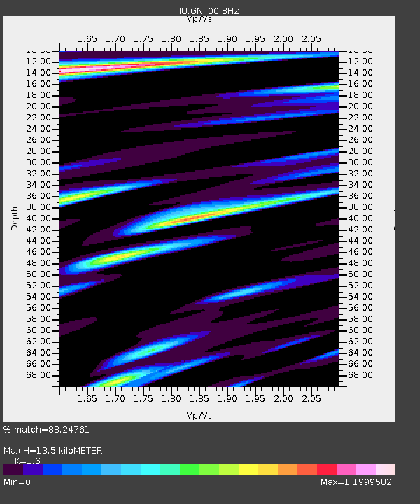
GNI Garni, Armenia - Earthquake Result Viewer
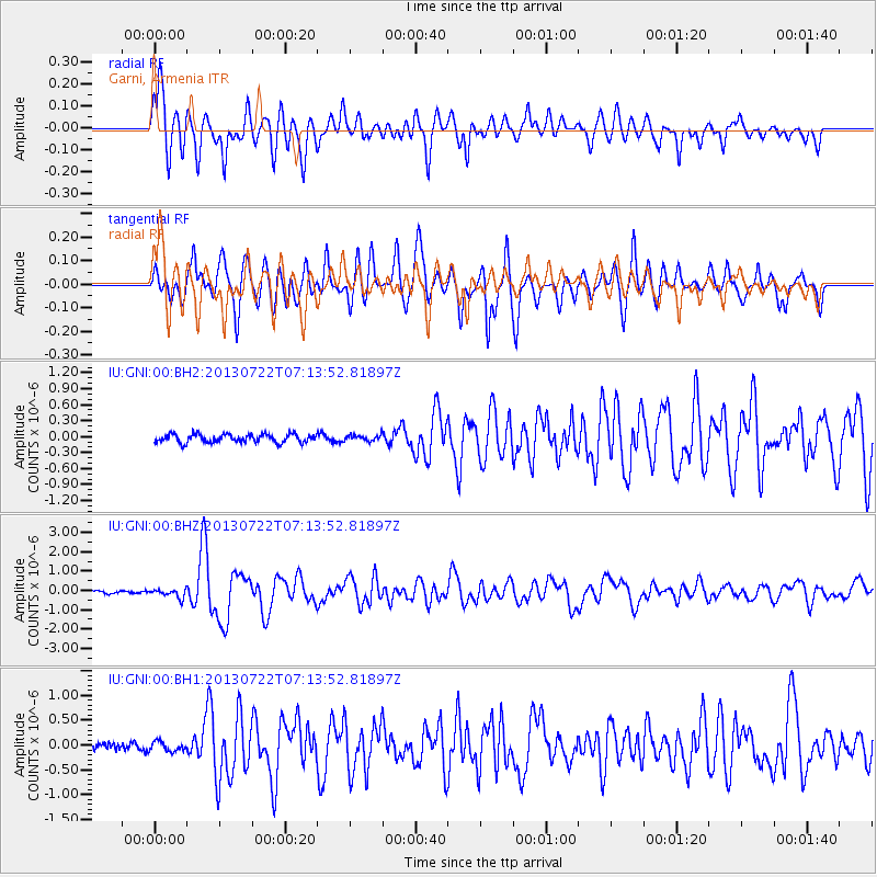
Earthquake location: Prince Edward Islands Region
Earthquake latitude/longitude: -46.0/34.8
Earthquake time(UTC): 2013/07/22 (203) 07:01:42 GMT
Earthquake Depth: 10 km
Earthquake Magnitude: 6.3 MW, 5.8 MB, 6.0 MS, 6.1 MW
Earthquake Catalog/Contributor: NEIC PDE/NEIC PDE-W
Network: IU Global Seismograph Network (GSN - IRIS/USGS)
Station: GNI Garni, Armenia
Lat/Lon: 40.15 N/44.74 E
Elevation: 1609 m
Distance: 86.3 deg
Az: 7.635 deg
Baz: 186.934 deg
Ray Param: 0.044166047
Estimated Moho Depth: 13.5 km
Estimated Crust Vp/Vs: 1.60
Assumed Crust Vp: 6.291 km/s
Estimated Crust Vs: 3.932 km/s
Estimated Crust Poisson's Ratio: 0.18
Radial Match: 88.24761 %
Radial Bump: 400
Transverse Match: 87.77027 %
Transverse Bump: 400
SOD ConfigId: 512894
Insert Time: 2013-09-16 00:08:44.225 +0000
GWidth: 2.5
Max Bumps: 400
Tol: 0.001

Signal To Noise

ChannelStoNSTALTA
IU:GNI:00:BHZ:20130722T07:13:52.81897Z3.03053712.2029025E-77.269017E-8
IU:GNI:00:BH1:20130722T07:13:52.81897Z1.1107869.565354E-88.611339E-8
IU:GNI:00:BH2:20130722T07:13:52.81897Z0.692093255.4448034E-87.8671526E-8
Arrivals
Ps1.3 SECOND
PpPs5.4 SECOND
PsPs/PpSs6.8 SECOND