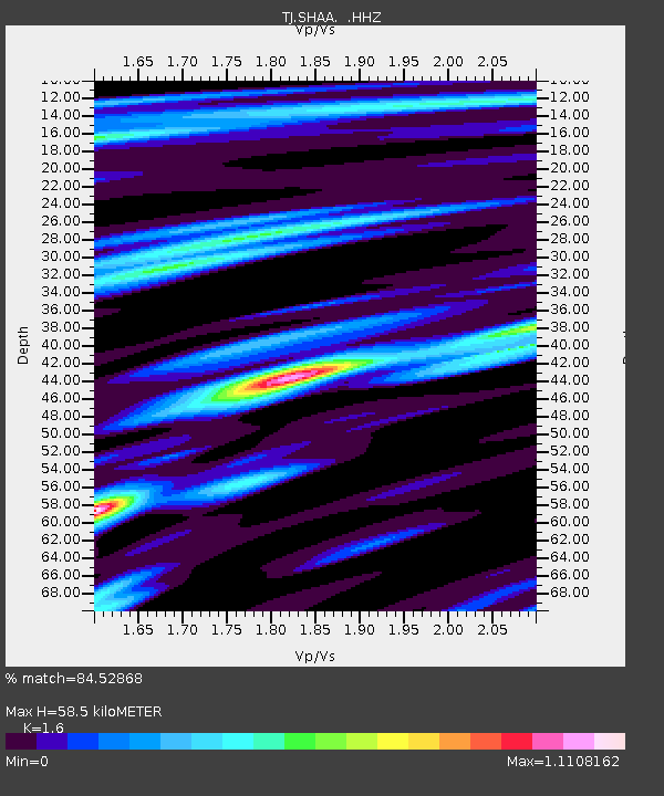
SHAA Shaartuz, Tajikistan - Earthquake Result Viewer

Earthquake location: Prince Edward Islands Region
Earthquake latitude/longitude: -46.0/34.8
Earthquake time(UTC): 2013/07/22 (203) 07:01:42 GMT
Earthquake Depth: 10 km
Earthquake Magnitude: 6.3 MW, 5.8 MB, 6.0 MS, 6.1 MW
Earthquake Catalog/Contributor: NEIC PDE/NEIC PDE-W
Network: TJ Tajikistan National Seismic Network
Station: SHAA Shaartuz, Tajikistan
Lat/Lon: 37.56 N/68.12 E
Elevation: 868 m
Distance: 88.5 deg
Az: 25.909 deg
Baz: 202.516 deg
Ray Param: 0.042564284
Estimated Moho Depth: 58.5 km
Estimated Crust Vp/Vs: 1.60
Assumed Crust Vp: 6.213 km/s
Estimated Crust Vs: 3.883 km/s
Estimated Crust Poisson's Ratio: 0.18
Radial Match: 84.52868 %
Radial Bump: 340
Transverse Match: 75.786934 %
Transverse Bump: 344
SOD ConfigId: 512894
Insert Time: 2013-09-16 00:11:24.691 +0000
GWidth: 2.5
Max Bumps: 400
Tol: 0.001

Signal To Noise

ChannelStoNSTALTA
TJ:SHAA: :HHZ:20130722T07:14:03.359985Z4.3735426.062056E-71.3860748E-7
TJ:SHAA: :HHN:20130722T07:14:03.359985Z1.27132742.336086E-71.8375172E-7
TJ:SHAA: :HHE:20130722T07:14:03.359985Z0.702590471.6487822E-72.3467189E-7
Arrivals
Ps5.8 SECOND
PpPs24 SECOND
PsPs/PpSs30 SECOND