You are here: Home > Network List > TA - USArray Transportable Network (new EarthScope stations) Stations List
> Station O03E Paynes Creek, CA, USA > Earthquake Result Viewer
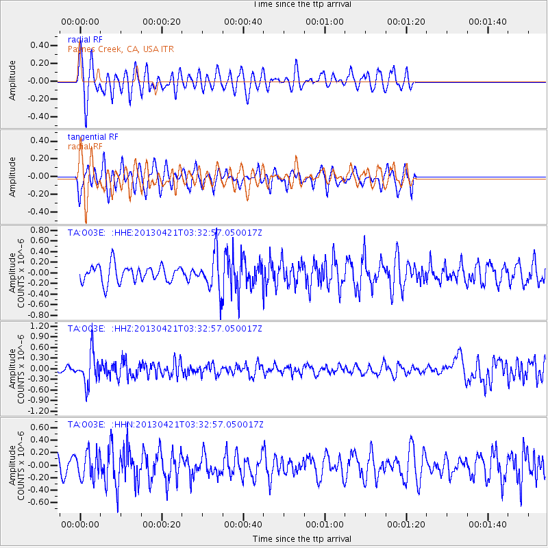
O03E Paynes Creek, CA, USA - Earthquake Result Viewer
*The percent match for this event was below the threshold and hence no stack was calculated.
| Earthquake location: |
Southeast Of Honshu, Japan |
| Earthquake latitude/longitude: |
29.9/138.9 |
| Earthquake time(UTC): |
2013/04/21 (111) 03:22:16 GMT |
| Earthquake Depth: |
422 km |
| Earthquake Magnitude: |
6.1 MW, 5.7 MB, 6.1 MW |
| Earthquake Catalog/Contributor: |
NEIC PDE/NEIC PDE-W |
|
| Network: |
TA USArray Transportable Network (new EarthScope stations) |
| Station: |
O03E Paynes Creek, CA, USA |
| Lat/Lon: |
40.29 N/121.80 W |
| Elevation: |
967 m |
|
| Distance: |
77.7 deg |
| Az: |
50.571 deg |
| Baz: |
298.763 deg |
| Ray Param: |
$rayparam |
*The percent match for this event was below the threshold and hence was not used in the summary stack. |
|
| Radial Match: |
67.77392 % |
| Radial Bump: |
400 |
| Transverse Match: |
57.68575 % |
| Transverse Bump: |
364 |
| SOD ConfigId: |
558458 |
| Insert Time: |
2013-09-16 17:40:30.908 +0000 |
| GWidth: |
2.5 |
| Max Bumps: |
400 |
| Tol: |
0.001 |
|
Signal To Noise
| Channel | StoN | STA | LTA |
| TA:O03E: :HHZ:20130421T03:32:57.050017Z | 5.197141 | 4.4768552E-7 | 8.614073E-8 |
| TA:O03E: :HHN:20130421T03:32:57.050017Z | 1.663106 | 2.0995259E-7 | 1.2624126E-7 |
| TA:O03E: :HHE:20130421T03:32:57.050017Z | 2.262299 | 3.5846188E-7 | 1.5845026E-7 |
| Arrivals |
| Ps | |
| PpPs | |
| PsPs/PpSs | |


