You are here: Home > Network List > WY - Yellowstone Wyoming Seismic Network Stations List
> Station YPP Pitchstone Plateau, YNP, WY, USA > Earthquake Result Viewer
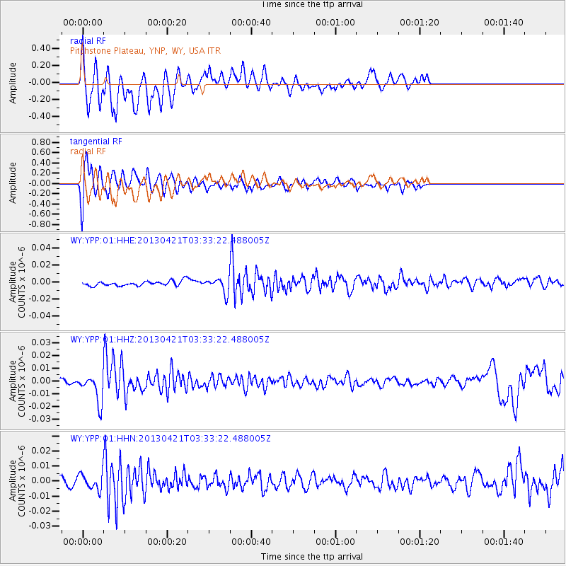
YPP Pitchstone Plateau, YNP, WY, USA - Earthquake Result Viewer
*The percent match for this event was below the threshold and hence no stack was calculated.
| Earthquake location: |
Southeast Of Honshu, Japan |
| Earthquake latitude/longitude: |
29.9/138.9 |
| Earthquake time(UTC): |
2013/04/21 (111) 03:22:16 GMT |
| Earthquake Depth: |
422 km |
| Earthquake Magnitude: |
6.1 MW, 5.7 MB, 6.1 MW |
| Earthquake Catalog/Contributor: |
NEIC PDE/NEIC PDE-W |
|
| Network: |
WY Yellowstone Wyoming Seismic Network |
| Station: |
YPP Pitchstone Plateau, YNP, WY, USA |
| Lat/Lon: |
44.27 N/110.80 W |
| Elevation: |
2707 m |
|
| Distance: |
82.6 deg |
| Az: |
42.797 deg |
| Baz: |
304.821 deg |
| Ray Param: |
$rayparam |
*The percent match for this event was below the threshold and hence was not used in the summary stack. |
|
| Radial Match: |
69.29233 % |
| Radial Bump: |
400 |
| Transverse Match: |
73.04287 % |
| Transverse Bump: |
400 |
| SOD ConfigId: |
558458 |
| Insert Time: |
2013-09-16 17:42:41.251 +0000 |
| GWidth: |
2.5 |
| Max Bumps: |
400 |
| Tol: |
0.001 |
|
Signal To Noise
| Channel | StoN | STA | LTA |
| WY:YPP:01:HHZ:20130421T03:33:22.488005Z | 6.3594027 | 1.1443226E-8 | 1.7994184E-9 |
| WY:YPP:01:HHN:20130421T03:33:22.488005Z | 2.6078568 | 5.5141824E-9 | 2.11445E-9 |
| WY:YPP:01:HHE:20130421T03:33:22.488005Z | 3.0758183 | 8.810174E-9 | 2.864335E-9 |
| Arrivals |
| Ps | |
| PpPs | |
| PsPs/PpSs | |


