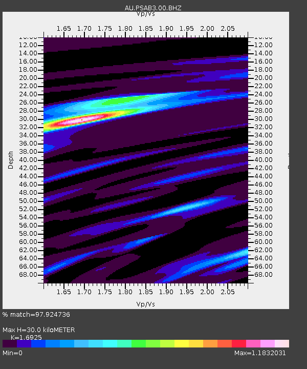
PSAB3 Pilbara Seismic Array Element B3 - Earthquake Result Viewer

Earthquake location: Philippine Islands Region
Earthquake latitude/longitude: 10.8/126.6
Earthquake time(UTC): 2012/08/31 (244) 12:47:33 GMT
Earthquake Depth: 28 km
Earthquake Magnitude: 7.6 MW, 7.2 MB, 7.6 MS, 7.6 MW
Earthquake Catalog/Contributor: NEIC PDE/NEIC PDE-W
Network: AU Australian Seismological Centre
Station: PSAB3 Pilbara Seismic Array Element B3
Lat/Lon: 21.59 S/119.85 E
Elevation: 327 m
Distance: 32.9 deg
Az: 191.681 deg
Baz: 12.341 deg
Ray Param: 0.078422144
Estimated Moho Depth: 30.0 km
Estimated Crust Vp/Vs: 1.69
Assumed Crust Vp: 6.464 km/s
Estimated Crust Vs: 3.819 km/s
Estimated Crust Poisson's Ratio: 0.23
Radial Match: 97.924736 %
Radial Bump: 273
Transverse Match: 84.690414 %
Transverse Bump: 400
SOD ConfigId: 558545
Insert Time: 2013-09-17 15:16:40.646 +0000
GWidth: 2.5
Max Bumps: 400
Tol: 0.001

Signal To Noise

ChannelStoNSTALTA
AU:PSAB3:00:BHZ:20120831T12:53:34.468989Z35.400032.26823E-56.407424E-7
AU:PSAB3:00:BH1:20120831T12:53:34.468989Z2.66755186.5840095E-72.4681844E-7
AU:PSAB3:00:BH2:20120831T12:53:34.468989Z24.704451.4561292E-55.894198E-7
Arrivals
Ps3.5 SECOND
PpPs11 SECOND
PsPs/PpSs15 SECOND