You are here: Home > Network List > IU - Global Seismograph Network (GSN - IRIS/USGS) Stations List
> Station GNI Garni, Armenia > Earthquake Result Viewer
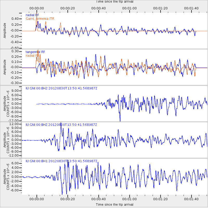
GNI Garni, Armenia - Earthquake Result Viewer
*The percent match for this event was below the threshold and hence no stack was calculated.
| Earthquake location: |
Jan Mayen Island Region |
| Earthquake latitude/longitude: |
71.4/-10.6 |
| Earthquake time(UTC): |
2012/08/30 (243) 13:43:25 GMT |
| Earthquake Depth: |
14 km |
| Earthquake Magnitude: |
6.7 MW, 5.9 MB, 6.3 MS, 6.8 MW |
| Earthquake Catalog/Contributor: |
NEIC PDE/NEIC PDE-W |
|
| Network: |
IU Global Seismograph Network (GSN - IRIS/USGS) |
| Station: |
GNI Garni, Armenia |
| Lat/Lon: |
40.15 N/44.74 E |
| Elevation: |
1609 m |
|
| Distance: |
41.6 deg |
| Az: |
108.196 deg |
| Baz: |
336.618 deg |
| Ray Param: |
$rayparam |
*The percent match for this event was below the threshold and hence was not used in the summary stack. |
|
| Radial Match: |
57.28819 % |
| Radial Bump: |
391 |
| Transverse Match: |
62.712345 % |
| Transverse Bump: |
400 |
| SOD ConfigId: |
558545 |
| Insert Time: |
2013-09-17 15:18:19.507 +0000 |
| GWidth: |
2.5 |
| Max Bumps: |
400 |
| Tol: |
0.001 |
|
Signal To Noise
| Channel | StoN | STA | LTA |
| IU:GNI:00:BHZ:20120830T13:50:41.568987Z | 3.4786713 | 2.653265E-7 | 7.627236E-8 |
| IU:GNI:00:BH1:20120830T13:50:41.568987Z | 1.2499022 | 1.5978053E-7 | 1.2783441E-7 |
| IU:GNI:00:BH2:20120830T13:50:41.568987Z | 0.63342506 | 6.977655E-8 | 1.10157536E-7 |
| Arrivals |
| Ps | |
| PpPs | |
| PsPs/PpSs | |


