You are here: Home > Network List > US - United States National Seismic Network Stations List
> Station DGMT Dagmar, Montana, USA > Earthquake Result Viewer
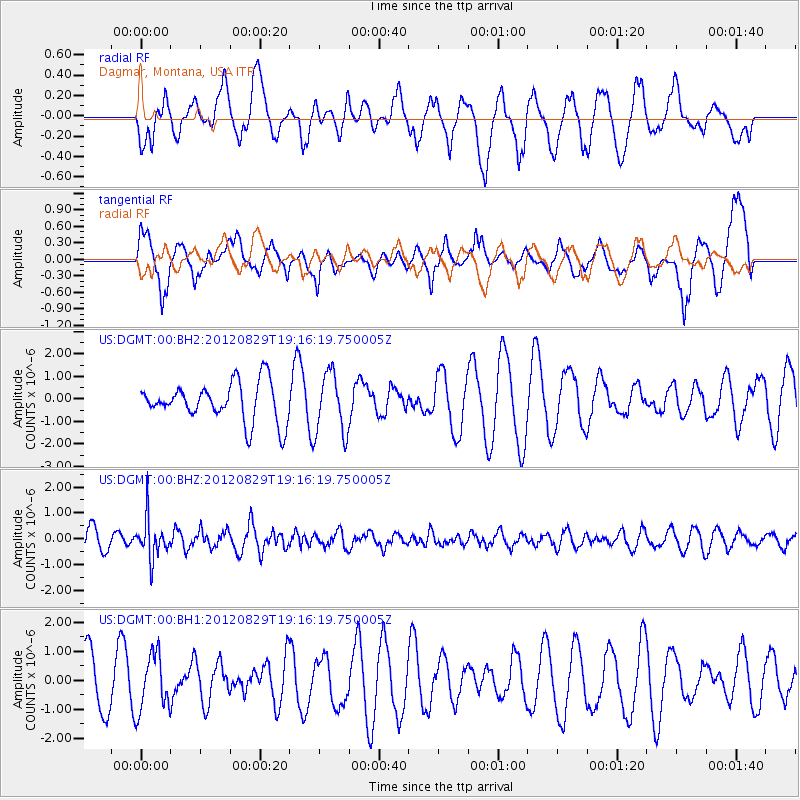
DGMT Dagmar, Montana, USA - Earthquake Result Viewer
*The percent match for this event was below the threshold and hence no stack was calculated.
| Earthquake location: |
Near East Coast Of Honshu, Japan |
| Earthquake latitude/longitude: |
38.4/141.8 |
| Earthquake time(UTC): |
2012/08/29 (242) 19:05:11 GMT |
| Earthquake Depth: |
47 km |
| Earthquake Magnitude: |
5.8 MB, 5.1 MS, 5.5 MW, 5.5 MW |
| Earthquake Catalog/Contributor: |
WHDF/NEIC |
|
| Network: |
US United States National Seismic Network |
| Station: |
DGMT Dagmar, Montana, USA |
| Lat/Lon: |
48.47 N/104.20 W |
| Elevation: |
0.0 m |
|
| Distance: |
75.6 deg |
| Az: |
38.892 deg |
| Baz: |
312.182 deg |
| Ray Param: |
$rayparam |
*The percent match for this event was below the threshold and hence was not used in the summary stack. |
|
| Radial Match: |
55.25186 % |
| Radial Bump: |
400 |
| Transverse Match: |
44.615395 % |
| Transverse Bump: |
400 |
| SOD ConfigId: |
558545 |
| Insert Time: |
2013-09-17 15:23:49.514 +0000 |
| GWidth: |
2.5 |
| Max Bumps: |
400 |
| Tol: |
0.001 |
|
Signal To Noise
| Channel | StoN | STA | LTA |
| US:DGMT:00:BHZ:20120829T19:16:19.750005Z | 2.1804805 | 7.6350165E-7 | 3.5015296E-7 |
| US:DGMT:00:BH1:20120829T19:16:19.750005Z | 0.98207784 | 9.695931E-7 | 9.872874E-7 |
| US:DGMT:00:BH2:20120829T19:16:19.750005Z | 1.5494285 | 1.3434931E-6 | 8.670895E-7 |
| Arrivals |
| Ps | |
| PpPs | |
| PsPs/PpSs | |


