You are here: Home > Network List > US - United States National Seismic Network Stations List
> Station DGMT Dagmar, Montana, USA > Earthquake Result Viewer
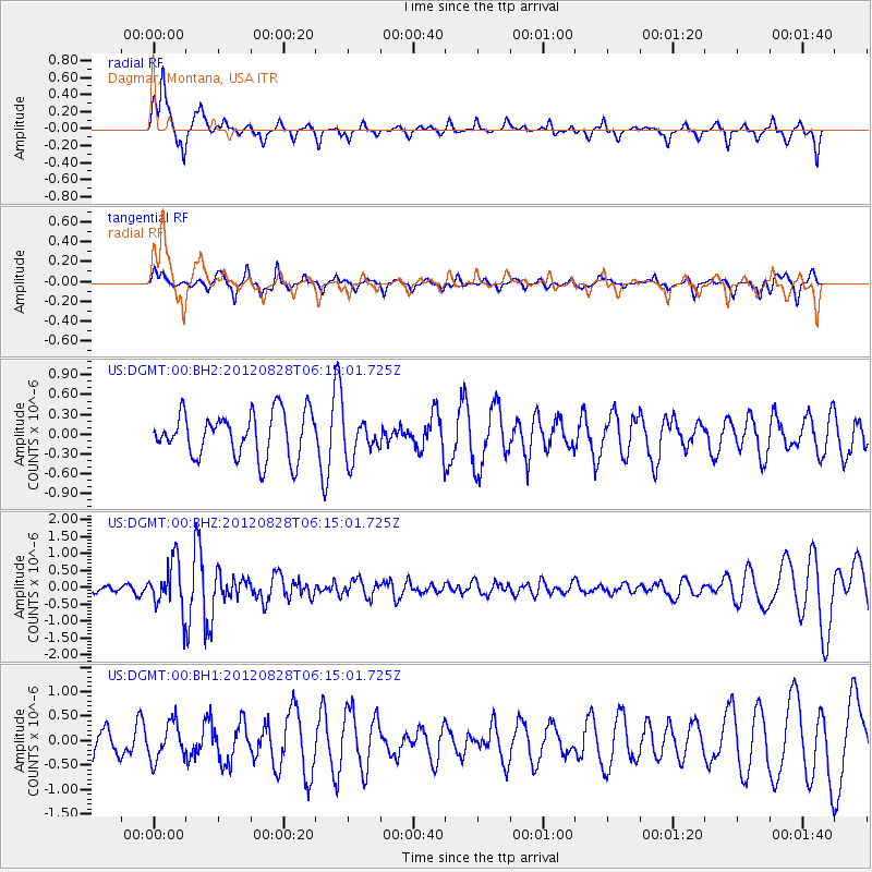
DGMT Dagmar, Montana, USA - Earthquake Result Viewer
*The percent match for this event was below the threshold and hence no stack was calculated.
| Earthquake location: |
Off Coast Of Central America |
| Earthquake latitude/longitude: |
12.5/-88.7 |
| Earthquake time(UTC): |
2012/08/28 (241) 06:08:16 GMT |
| Earthquake Depth: |
35 km |
| Earthquake Magnitude: |
5.5 MW, 5.0 MS, 5.1 MB, 5.5 MW |
| Earthquake Catalog/Contributor: |
WHDF/NEIC |
|
| Network: |
US United States National Seismic Network |
| Station: |
DGMT Dagmar, Montana, USA |
| Lat/Lon: |
48.47 N/104.20 W |
| Elevation: |
0.0 m |
|
| Distance: |
38.2 deg |
| Az: |
343.227 deg |
| Baz: |
154.942 deg |
| Ray Param: |
$rayparam |
*The percent match for this event was below the threshold and hence was not used in the summary stack. |
|
| Radial Match: |
74.316505 % |
| Radial Bump: |
378 |
| Transverse Match: |
60.97617 % |
| Transverse Bump: |
340 |
| SOD ConfigId: |
558545 |
| Insert Time: |
2013-09-17 15:27:28.997 +0000 |
| GWidth: |
2.5 |
| Max Bumps: |
400 |
| Tol: |
0.001 |
|
Signal To Noise
| Channel | StoN | STA | LTA |
| US:DGMT:00:BHZ:20120828T06:15:01.725Z | 3.722948 | 7.1032173E-7 | 1.9079549E-7 |
| US:DGMT:00:BH1:20120828T06:15:01.725Z | 1.110727 | 3.797906E-7 | 3.4192976E-7 |
| US:DGMT:00:BH2:20120828T06:15:01.725Z | 0.91006476 | 3.0763357E-7 | 3.380348E-7 |
| Arrivals |
| Ps | |
| PpPs | |
| PsPs/PpSs | |


