You are here: Home > Network List > IU - Global Seismograph Network (GSN - IRIS/USGS) Stations List
> Station RSSD Black Hills, South Dakota, USA > Earthquake Result Viewer
RSSD Black Hills, South Dakota, USA - Earthquake Result Viewer
*The percent match for this event was below the threshold and hence no stack was calculated.
| Earthquake location: |
Off Coast Of Central America |
| Earthquake latitude/longitude: |
12.3/-88.6 |
| Earthquake time(UTC): |
2012/08/27 (240) 05:38:04 GMT |
| Earthquake Depth: |
35 km |
| Earthquake Magnitude: |
5.5 MB |
| Earthquake Catalog/Contributor: |
WHDF/NEIC |
|
| Network: |
IU Global Seismograph Network (GSN - IRIS/USGS) |
| Station: |
RSSD Black Hills, South Dakota, USA |
| Lat/Lon: |
44.12 N/104.04 W |
| Elevation: |
2090 m |
|
| Distance: |
34.4 deg |
| Az: |
340.169 deg |
| Baz: |
152.589 deg |
| Ray Param: |
$rayparam |
*The percent match for this event was below the threshold and hence was not used in the summary stack. |
|
| Radial Match: |
62.71484 % |
| Radial Bump: |
298 |
| Transverse Match: |
74.75091 % |
| Transverse Bump: |
338 |
| SOD ConfigId: |
558545 |
| Insert Time: |
2013-09-17 15:29:39.966 +0000 |
| GWidth: |
2.5 |
| Max Bumps: |
400 |
| Tol: |
0.001 |
|
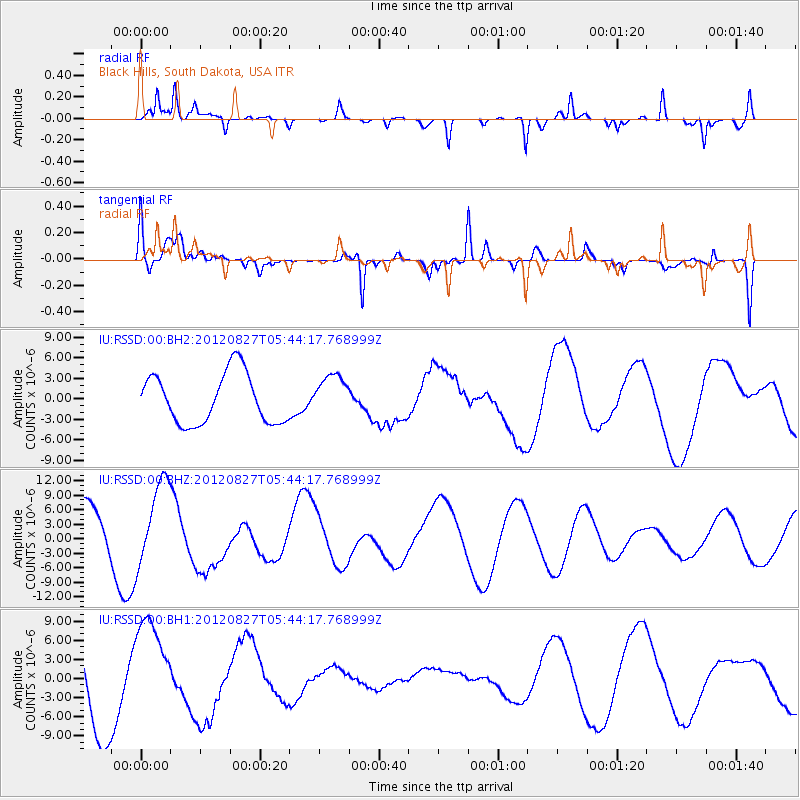
Signal To Noise
| Channel | StoN | STA | LTA |
| IU:RSSD:00:BHZ:20120827T05:44:17.768999Z | 2.4439132 | 8.734562E-6 | 3.5740063E-6 |
| IU:RSSD:00:BH1:20120827T05:44:17.768999Z | 1.6915857 | 7.778853E-6 | 4.5985566E-6 |
| IU:RSSD:00:BH2:20120827T05:44:17.768999Z | 0.8321562 | 3.0328092E-6 | 3.6445192E-6 |
| Arrivals |
| Ps | |
| PpPs | |
| PsPs/PpSs | |


