You are here: Home > Network List > II - Global Seismograph Network (GSN - IRIS/IDA) Stations List
> Station NIL Nilore, Pakistan > Earthquake Result Viewer
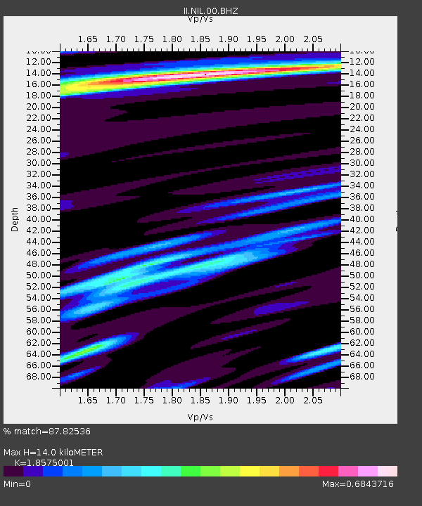
NIL Nilore, Pakistan - Earthquake Result Viewer
| Earthquake location: |
Northern Molucca Sea |
| Earthquake latitude/longitude: |
2.2/126.8 |
| Earthquake time(UTC): |
2012/08/26 (239) 15:05:37 GMT |
| Earthquake Depth: |
91 km |
| Earthquake Magnitude: |
6.3 MB, 6.6 MW, 6.6 MW |
| Earthquake Catalog/Contributor: |
WHDF/NEIC |
|
| Network: |
II Global Seismograph Network (GSN - IRIS/IDA) |
| Station: |
NIL Nilore, Pakistan |
| Lat/Lon: |
33.65 N/73.27 E |
| Elevation: |
629 m |
|
| Distance: |
58.9 deg |
| Az: |
308.422 deg |
| Baz: |
110.19 deg |
| Ray Param: |
0.062257662 |
| Estimated Moho Depth: |
14.0 km |
| Estimated Crust Vp/Vs: |
1.86 |
| Assumed Crust Vp: |
6.242 km/s |
| Estimated Crust Vs: |
3.36 km/s |
| Estimated Crust Poisson's Ratio: |
0.30 |
|
| Radial Match: |
87.82536 % |
| Radial Bump: |
400 |
| Transverse Match: |
81.3008 % |
| Transverse Bump: |
400 |
| SOD ConfigId: |
558545 |
| Insert Time: |
2013-09-17 15:33:27.574 +0000 |
| GWidth: |
2.5 |
| Max Bumps: |
400 |
| Tol: |
0.001 |
|

Signal To Noise
| Channel | StoN | STA | LTA |
| II:NIL:00:BHZ:20120826T15:14:56.168989Z | 30.969646 | 4.3077544E-6 | 1.3909602E-7 |
| II:NIL:00:BH1:20120826T15:14:56.168989Z | 2.229344 | 1.8957518E-7 | 8.503631E-8 |
| II:NIL:00:BH2:20120826T15:14:56.168989Z | 8.515925 | 5.6517973E-7 | 6.636739E-8 |
| Arrivals |
| Ps | 2.0 SECOND |
| PpPs | 6.1 SECOND |
| PsPs/PpSs | 8.1 SECOND |


