You are here: Home > Network List > IU - Global Seismograph Network (GSN - IRIS/USGS) Stations List
> Station HNR Honiara, Solomon Islands > Earthquake Result Viewer
HNR Honiara, Solomon Islands - Earthquake Result Viewer
| Earthquake location: |
Northern Molucca Sea |
| Earthquake latitude/longitude: |
2.2/126.8 |
| Earthquake time(UTC): |
2012/08/26 (239) 15:05:37 GMT |
| Earthquake Depth: |
91 km |
| Earthquake Magnitude: |
6.3 MB, 6.6 MW, 6.6 MW |
| Earthquake Catalog/Contributor: |
WHDF/NEIC |
|
| Network: |
IU Global Seismograph Network (GSN - IRIS/USGS) |
| Station: |
HNR Honiara, Solomon Islands |
| Lat/Lon: |
9.44 S/159.95 E |
| Elevation: |
100 m |
|
| Distance: |
35.0 deg |
| Az: |
109.813 deg |
| Baz: |
287.663 deg |
| Ray Param: |
0.07719815 |
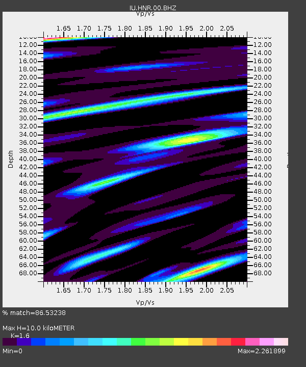
| Estimated Moho Depth: |
10.0 km |
| Estimated Crust Vp/Vs: |
1.60 |
| Assumed Crust Vp: |
6.183 km/s |
| Estimated Crust Vs: |
3.864 km/s |
| Estimated Crust Poisson's Ratio: |
0.18 |
|
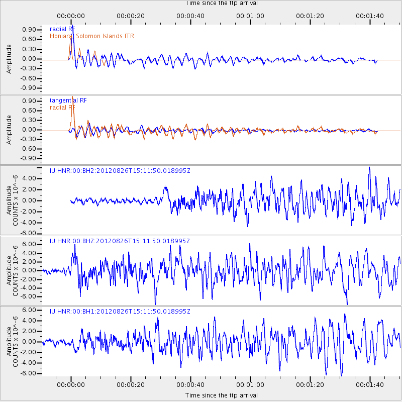
| Radial Match: |
86.53238 % |
| Radial Bump: |
400 |
| Transverse Match: |
78.59546 % |
| Transverse Bump: |
400 |
| SOD ConfigId: |
558545 |
| Insert Time: |
2013-09-17 15:34:03.785 +0000 |
| GWidth: |
2.5 |
| Max Bumps: |
400 |
| Tol: |
0.001 |
|
Signal To Noise
| Channel | StoN | STA | LTA |
| IU:HNR:00:BHZ:20120826T15:11:50.018995Z | 7.0649724 | 2.5880308E-6 | 3.663186E-7 |
| IU:HNR:00:BH1:20120826T15:11:50.018995Z | 3.6080236 | 1.1635925E-6 | 3.2250134E-7 |
| IU:HNR:00:BH2:20120826T15:11:50.018995Z | 4.758642 | 1.3637898E-6 | 2.865922E-7 |
| Arrivals |
| Ps | 1.0 SECOND |
| PpPs | 3.9 SECOND |
| PsPs/PpSs | 4.9 SECOND |


