You are here: Home > Network List > IU - Global Seismograph Network (GSN - IRIS/USGS) Stations List
> Station NWAO Narrogin, Australia > Earthquake Result Viewer
NWAO Narrogin, Australia - Earthquake Result Viewer
| Earthquake location: |
Northern Molucca Sea |
| Earthquake latitude/longitude: |
2.2/126.8 |
| Earthquake time(UTC): |
2012/08/26 (239) 15:05:37 GMT |
| Earthquake Depth: |
91 km |
| Earthquake Magnitude: |
6.3 MB, 6.6 MW, 6.6 MW |
| Earthquake Catalog/Contributor: |
WHDF/NEIC |
|
| Network: |
IU Global Seismograph Network (GSN - IRIS/USGS) |
| Station: |
NWAO Narrogin, Australia |
| Lat/Lon: |
32.93 S/117.24 E |
| Elevation: |
380 m |
|
| Distance: |
36.1 deg |
| Az: |
193.772 deg |
| Baz: |
16.431 deg |
| Ray Param: |
0.07658354 |
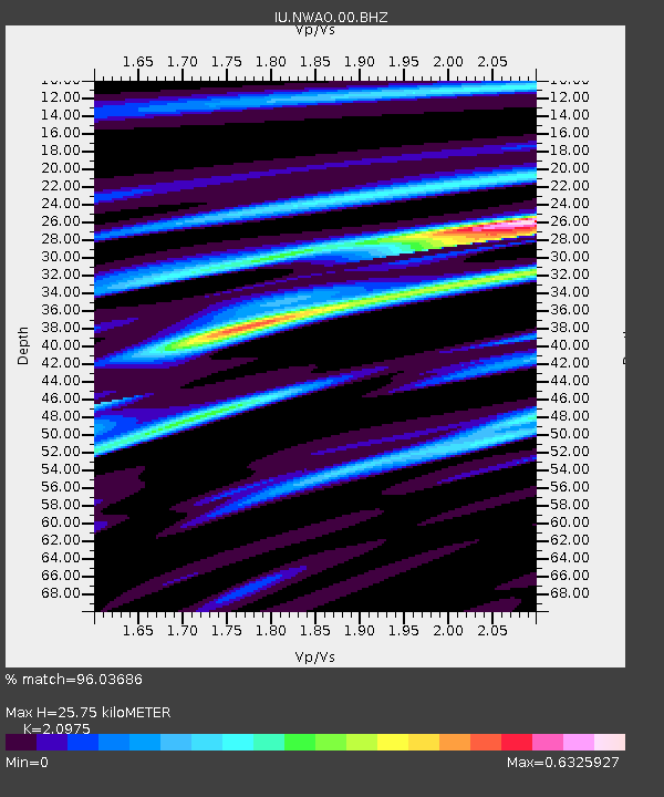
| Estimated Moho Depth: |
25.75 km |
| Estimated Crust Vp/Vs: |
2.10 |
| Assumed Crust Vp: |
6.419 km/s |
| Estimated Crust Vs: |
3.06 km/s |
| Estimated Crust Poisson's Ratio: |
0.35 |
|
| Radial Match: |
96.03686 % |
| Radial Bump: |
183 |
| Transverse Match: |
84.54532 % |
| Transverse Bump: |
400 |
| SOD ConfigId: |
558545 |
| Insert Time: |
2013-09-17 15:34:24.217 +0000 |
| GWidth: |
2.5 |
| Max Bumps: |
400 |
| Tol: |
0.001 |
|
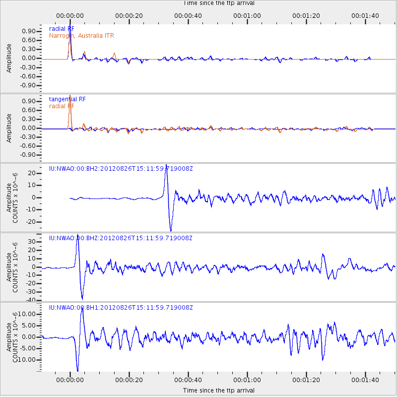
Signal To Noise
| Channel | StoN | STA | LTA |
| IU:NWAO:00:BHZ:20120826T15:11:59.719008Z | 31.8958 | 1.9791005E-5 | 6.204894E-7 |
| IU:NWAO:00:BH1:20120826T15:11:59.719008Z | 13.158267 | 7.1894087E-6 | 5.463796E-7 |
| IU:NWAO:00:BH2:20120826T15:11:59.719008Z | 33.978264 | 1.4131025E-5 | 4.1588424E-7 |
| Arrivals |
| Ps | 4.7 SECOND |
| PpPs | 12 SECOND |
| PsPs/PpSs | 16 SECOND |


