You are here: Home > Network List > IU - Global Seismograph Network (GSN - IRIS/USGS) Stations List
> Station HNR Honiara, Solomon Islands > Earthquake Result Viewer
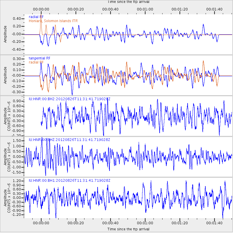
HNR Honiara, Solomon Islands - Earthquake Result Viewer
*The percent match for this event was below the threshold and hence no stack was calculated.
| Earthquake location: |
Pacific-Antarctic Ridge |
| Earthquake latitude/longitude: |
-65.5/-179.8 |
| Earthquake time(UTC): |
2012/08/26 (239) 11:22:22 GMT |
| Earthquake Depth: |
10 km |
| Earthquake Magnitude: |
5.6 MW, 5.6 MW |
| Earthquake Catalog/Contributor: |
NEIC PDE/NEIC PDE-W |
|
| Network: |
IU Global Seismograph Network (GSN - IRIS/USGS) |
| Station: |
HNR Honiara, Solomon Islands |
| Lat/Lon: |
9.44 S/159.95 E |
| Elevation: |
100 m |
|
| Distance: |
57.7 deg |
| Az: |
336.142 deg |
| Baz: |
170.149 deg |
| Ray Param: |
$rayparam |
*The percent match for this event was below the threshold and hence was not used in the summary stack. |
|
| Radial Match: |
65.31019 % |
| Radial Bump: |
400 |
| Transverse Match: |
52.833332 % |
| Transverse Bump: |
400 |
| SOD ConfigId: |
558545 |
| Insert Time: |
2013-09-17 15:35:32.102 +0000 |
| GWidth: |
2.5 |
| Max Bumps: |
400 |
| Tol: |
0.001 |
|
Signal To Noise
| Channel | StoN | STA | LTA |
| IU:HNR:00:BHZ:20120826T11:31:41.719028Z | 2.2318928 | 9.862995E-7 | 4.4191165E-7 |
| IU:HNR:00:BH1:20120826T11:31:41.719028Z | 1.1309022 | 4.5246986E-7 | 4.0009638E-7 |
| IU:HNR:00:BH2:20120826T11:31:41.719028Z | 1.3620734 | 5.371205E-7 | 3.9434033E-7 |
| Arrivals |
| Ps | |
| PpPs | |
| PsPs/PpSs | |


