You are here: Home > Network List > US - United States National Seismic Network Stations List
> Station DUG Dugway, Tooele County, Utah, USA > Earthquake Result Viewer
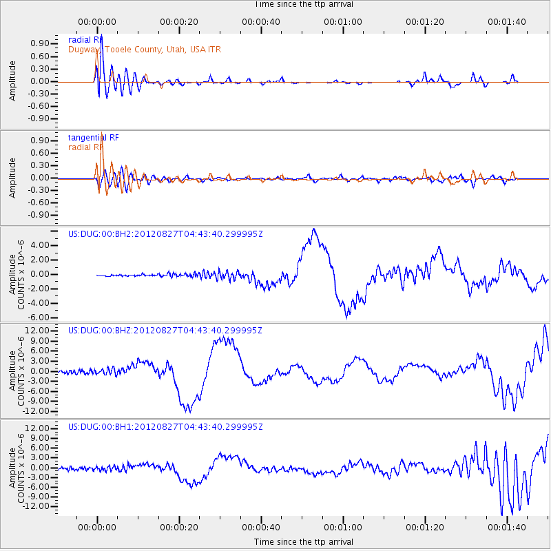
DUG Dugway, Tooele County, Utah, USA - Earthquake Result Viewer
*The percent match for this event was below the threshold and hence no stack was calculated.
| Earthquake location: |
Off Coast Of Central America |
| Earthquake latitude/longitude: |
12.1/-88.6 |
| Earthquake time(UTC): |
2012/08/27 (240) 04:37:19 GMT |
| Earthquake Depth: |
28 km |
| Earthquake Magnitude: |
6.0 MB, 6.9 MS, 7.3 MW, 7.4 MW |
| Earthquake Catalog/Contributor: |
WHDF/NEIC |
|
| Network: |
US United States National Seismic Network |
| Station: |
DUG Dugway, Tooele County, Utah, USA |
| Lat/Lon: |
40.19 N/112.81 W |
| Elevation: |
1477 m |
|
| Distance: |
35.2 deg |
| Az: |
326.933 deg |
| Baz: |
135.847 deg |
| Ray Param: |
$rayparam |
*The percent match for this event was below the threshold and hence was not used in the summary stack. |
|
| Radial Match: |
79.3114 % |
| Radial Bump: |
400 |
| Transverse Match: |
42.420456 % |
| Transverse Bump: |
400 |
| SOD ConfigId: |
558545 |
| Insert Time: |
2013-09-17 15:38:41.433 +0000 |
| GWidth: |
2.5 |
| Max Bumps: |
400 |
| Tol: |
0.001 |
|
Signal To Noise
| Channel | StoN | STA | LTA |
| US:DUG:00:BHZ:20120827T04:43:40.299995Z | 3.7126057 | 8.6452167E-7 | 2.3286115E-7 |
| US:DUG:00:BH1:20120827T04:43:40.299995Z | 2.5655801 | 6.3460465E-7 | 2.4735328E-7 |
| US:DUG:00:BH2:20120827T04:43:40.299995Z | 3.514956 | 5.074129E-7 | 1.4435825E-7 |
| Arrivals |
| Ps | |
| PpPs | |
| PsPs/PpSs | |


