You are here: Home > Network List > US - United States National Seismic Network Stations List
> Station LONY Lake Ozonia, New York, USA > Earthquake Result Viewer
LONY Lake Ozonia, New York, USA - Earthquake Result Viewer
| Earthquake location: |
Off Coast Of Central America |
| Earthquake latitude/longitude: |
12.1/-88.6 |
| Earthquake time(UTC): |
2012/08/27 (240) 04:37:19 GMT |
| Earthquake Depth: |
28 km |
| Earthquake Magnitude: |
6.0 MB, 6.9 MS, 7.3 MW, 7.4 MW |
| Earthquake Catalog/Contributor: |
WHDF/NEIC |
|
| Network: |
US United States National Seismic Network |
| Station: |
LONY Lake Ozonia, New York, USA |
| Lat/Lon: |
44.62 N/74.58 W |
| Elevation: |
440 m |
|
| Distance: |
34.5 deg |
| Az: |
17.756 deg |
| Baz: |
204.685 deg |
| Ray Param: |
0.07765066 |
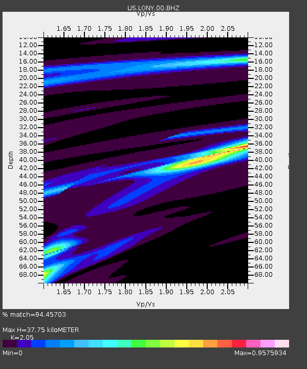
| Estimated Moho Depth: |
37.75 km |
| Estimated Crust Vp/Vs: |
2.05 |
| Assumed Crust Vp: |
6.419 km/s |
| Estimated Crust Vs: |
3.131 km/s |
| Estimated Crust Poisson's Ratio: |
0.34 |
|
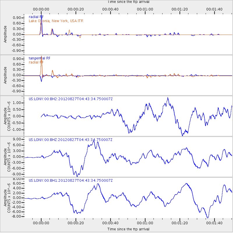
| Radial Match: |
94.45703 % |
| Radial Bump: |
189 |
| Transverse Match: |
92.17271 % |
| Transverse Bump: |
337 |
| SOD ConfigId: |
558545 |
| Insert Time: |
2013-09-17 15:39:18.548 +0000 |
| GWidth: |
2.5 |
| Max Bumps: |
400 |
| Tol: |
0.001 |
|
Signal To Noise
| Channel | StoN | STA | LTA |
| US:LONY:00:BHZ:20120827T04:43:34.750007Z | 3.5639923 | 4.3455321E-7 | 1.2192878E-7 |
| US:LONY:00:BH1:20120827T04:43:34.750007Z | 2.085258 | 2.583167E-7 | 1.2387757E-7 |
| US:LONY:00:BH2:20120827T04:43:34.750007Z | 0.80337423 | 6.604587E-8 | 8.221058E-8 |
| Arrivals |
| Ps | 6.6 SECOND |
| PpPs | 17 SECOND |
| PsPs/PpSs | 23 SECOND |


