You are here: Home > Network List > IU - Global Seismograph Network (GSN - IRIS/USGS) Stations List
> Station HNR Honiara, Solomon Islands > Earthquake Result Viewer
HNR Honiara, Solomon Islands - Earthquake Result Viewer
| Earthquake location: |
South Of Java, Indonesia |
| Earthquake latitude/longitude: |
-10.7/113.9 |
| Earthquake time(UTC): |
2012/09/03 (247) 18:23:05 GMT |
| Earthquake Depth: |
14 km |
| Earthquake Magnitude: |
6.4 MB, 6.1 MS, 6.1 MW, 6.2 MW |
| Earthquake Catalog/Contributor: |
WHDF/NEIC |
|
| Network: |
IU Global Seismograph Network (GSN - IRIS/USGS) |
| Station: |
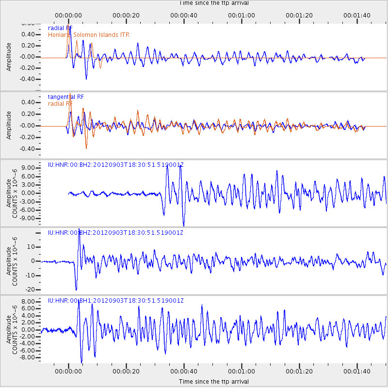
HNR Honiara, Solomon Islands |
| Lat/Lon: |
9.44 S/159.95 E |
| Elevation: |
100 m |
|
| Distance: |
45.3 deg |
| Az: |
92.713 deg |
| Baz: |
264.272 deg |
| Ray Param: |
0.07136253 |
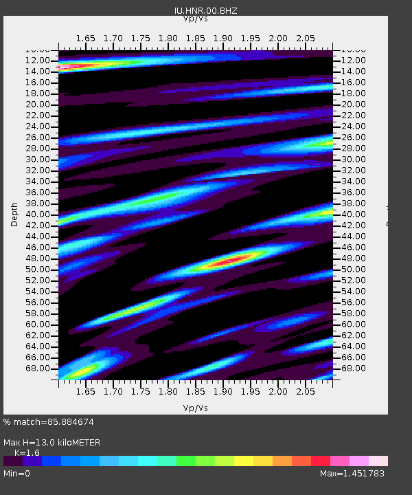
| Estimated Moho Depth: |
13.0 km |
| Estimated Crust Vp/Vs: |
1.60 |
| Assumed Crust Vp: |
6.183 km/s |
| Estimated Crust Vs: |
3.864 km/s |
| Estimated Crust Poisson's Ratio: |
0.18 |
|
| Radial Match: |
85.884674 % |
| Radial Bump: |
390 |
| Transverse Match: |
83.5472 % |
| Transverse Bump: |
400 |
| SOD ConfigId: |
558545 |
| Insert Time: |
2013-09-17 15:49:35.525 +0000 |
| GWidth: |
2.5 |
| Max Bumps: |
400 |
| Tol: |
0.001 |
|
Signal To Noise
| Channel | StoN | STA | LTA |
| IU:HNR:00:BHZ:20120903T18:30:51.519001Z | 26.157265 | 9.190879E-6 | 3.5137003E-7 |
| IU:HNR:00:BH1:20120903T18:30:51.519001Z | 8.108183 | 3.849671E-6 | 4.7478838E-7 |
| IU:HNR:00:BH2:20120903T18:30:51.519001Z | 10.018607 | 4.1221206E-6 | 4.1144645E-7 |
| Arrivals |
| Ps | 1.3 SECOND |
| PpPs | 5.1 SECOND |
| PsPs/PpSs | 6.5 SECOND |


