You are here: Home > Network List > IU - Global Seismograph Network (GSN - IRIS/USGS) Stations List
> Station MA2 Magadan, Russia > Earthquake Result Viewer
MA2 Magadan, Russia - Earthquake Result Viewer
| Earthquake location: |
South Of Java, Indonesia |
| Earthquake latitude/longitude: |
-10.7/113.9 |
| Earthquake time(UTC): |
2012/09/03 (247) 18:23:05 GMT |
| Earthquake Depth: |
14 km |
| Earthquake Magnitude: |
6.4 MB, 6.1 MS, 6.1 MW, 6.2 MW |
| Earthquake Catalog/Contributor: |
WHDF/NEIC |
|
| Network: |
IU Global Seismograph Network (GSN - IRIS/USGS) |
| Station: |
MA2 Magadan, Russia |
| Lat/Lon: |
59.58 N/150.77 E |
| Elevation: |
339 m |
|
| Distance: |
76.0 deg |
| Az: |
18.327 deg |
| Baz: |
217.389 deg |
| Ray Param: |
0.051260967 |
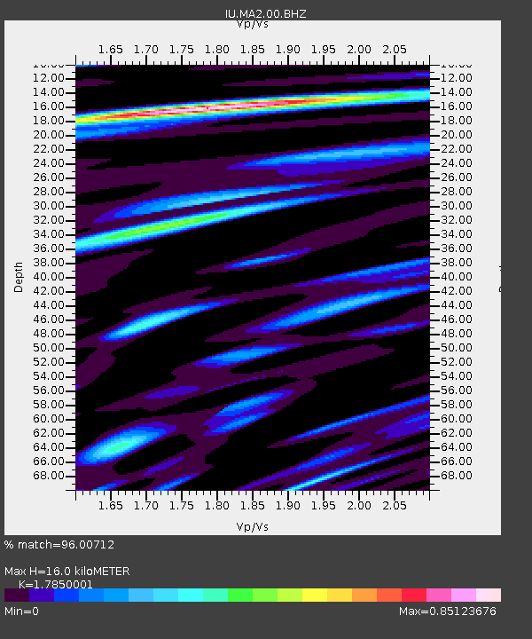
| Estimated Moho Depth: |
16.0 km |
| Estimated Crust Vp/Vs: |
1.79 |
| Assumed Crust Vp: |
6.134 km/s |
| Estimated Crust Vs: |
3.436 km/s |
| Estimated Crust Poisson's Ratio: |
0.27 |
|
| Radial Match: |
96.00712 % |
| Radial Bump: |
400 |
| Transverse Match: |
90.61969 % |
| Transverse Bump: |
400 |
| SOD ConfigId: |
558545 |
| Insert Time: |
2013-09-17 15:49:49.401 +0000 |
| GWidth: |
2.5 |
| Max Bumps: |
400 |
| Tol: |
0.001 |
|
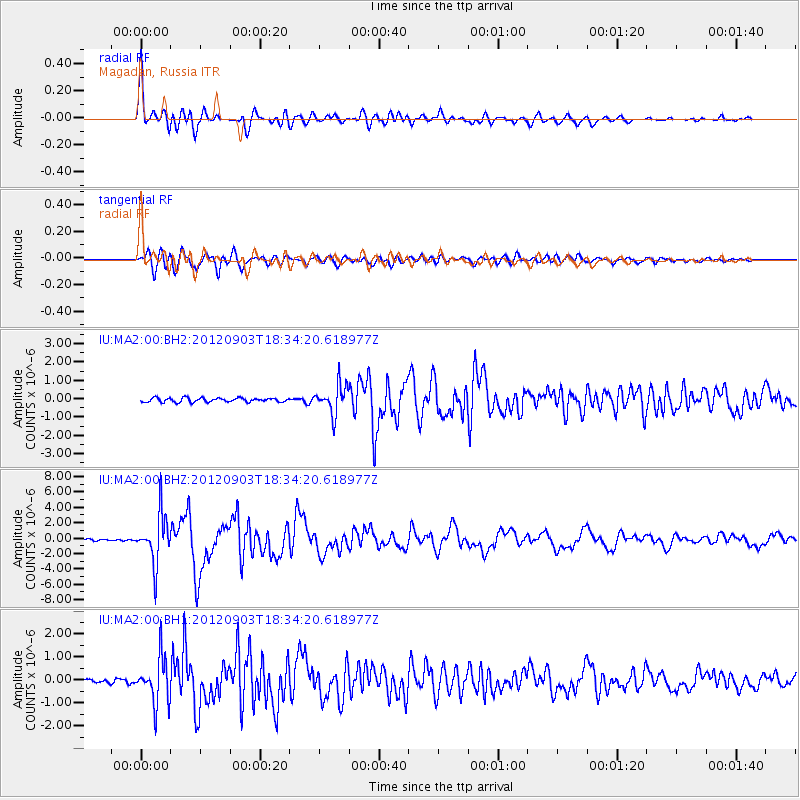
Signal To Noise
| Channel | StoN | STA | LTA |
| IU:MA2:00:BHZ:20120903T18:34:20.618977Z | 30.592709 | 3.1442976E-6 | 1.0277932E-7 |
| IU:MA2:00:BH1:20120903T18:34:20.618977Z | 13.203192 | 9.884296E-7 | 7.486293E-8 |
| IU:MA2:00:BH2:20120903T18:34:20.618977Z | 7.199696 | 7.874336E-7 | 1.0937039E-7 |
| Arrivals |
| Ps | 2.1 SECOND |
| PpPs | 7.1 SECOND |
| PsPs/PpSs | 9.2 SECOND |


