You are here: Home > Network List > US - United States National Seismic Network Stations List
> Station DGMT Dagmar, Montana, USA > Earthquake Result Viewer
DGMT Dagmar, Montana, USA - Earthquake Result Viewer

| Earthquake location: |
Costa Rica |
| Earthquake latitude/longitude: |
10.1/-85.3 |
| Earthquake time(UTC): |
2012/09/05 (249) 14:42:07 GMT |
| Earthquake Depth: |
35 km |
| Earthquake Magnitude: |
7.6 MW, 6.8 MB, 7.6 MW, 7.7 MS |
| Earthquake Catalog/Contributor: |
NEIC PDE/NEIC PDE-W |
|
| Network: |
US United States National Seismic Network |
| Station: |
DGMT Dagmar, Montana, USA |
| Lat/Lon: |
48.47 N/104.20 W |
| Elevation: |
0.0 m |
|
| Distance: |
41.4 deg |
| Az: |
341.001 deg |
| Baz: |
151.202 deg |
| Ray Param: |
0.073733285 |
| Estimated Moho Depth: |
18.25 km |
| Estimated Crust Vp/Vs: |
1.69 |
| Assumed Crust Vp: |
6.438 km/s |
| Estimated Crust Vs: |
3.809 km/s |
| Estimated Crust Poisson's Ratio: |
0.23 |
|
| Radial Match: |
90.116684 % |
| Radial Bump: |
400 |
| Transverse Match: |
66.1854 % |
| Transverse Bump: |
400 |
| SOD ConfigId: |
558545 |
| Insert Time: |
2013-09-17 15:52:26.188 +0000 |
| GWidth: |
2.5 |
| Max Bumps: |
400 |
| Tol: |
0.001 |
|
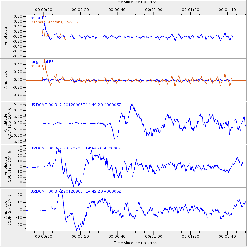
Signal To Noise
| Channel | StoN | STA | LTA |
| US:DGMT:00:BHZ:20120905T14:49:20.400006Z | 17.751534 | 3.7184702E-6 | 2.094732E-7 |
| US:DGMT:00:BH1:20120905T14:49:20.400006Z | 5.05805 | 2.1066821E-6 | 4.1650088E-7 |
| US:DGMT:00:BH2:20120905T14:49:20.400006Z | 3.132651 | 1.3251764E-6 | 4.2302074E-7 |
| Arrivals |
| Ps | 2.1 SECOND |
| PpPs | 7.1 SECOND |
| PsPs/PpSs | 9.2 SECOND |


