You are here: Home > Network List > US - United States National Seismic Network Stations List
> Station EGMT Eagleton, Montana, USA > Earthquake Result Viewer
EGMT Eagleton, Montana, USA - Earthquake Result Viewer
| Earthquake location: |
Costa Rica |
| Earthquake latitude/longitude: |
10.1/-85.3 |
| Earthquake time(UTC): |
2012/09/05 (249) 14:42:07 GMT |
| Earthquake Depth: |
35 km |
| Earthquake Magnitude: |
7.6 MW, 6.8 MB, 7.6 MW, 7.7 MS |
| Earthquake Catalog/Contributor: |
NEIC PDE/NEIC PDE-W |
|
| Network: |
US United States National Seismic Network |
| Station: |
EGMT Eagleton, Montana, USA |
| Lat/Lon: |
48.02 N/109.75 W |
| Elevation: |
1055 m |
|
| Distance: |
43.0 deg |
| Az: |
335.991 deg |
| Baz: |
143.355 deg |
| Ray Param: |
0.07272877 |
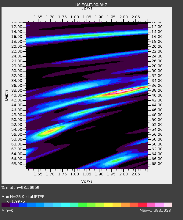
| Estimated Moho Depth: |
38.0 km |
| Estimated Crust Vp/Vs: |
2.00 |
| Assumed Crust Vp: |
6.438 km/s |
| Estimated Crust Vs: |
3.223 km/s |
| Estimated Crust Poisson's Ratio: |
0.33 |
|
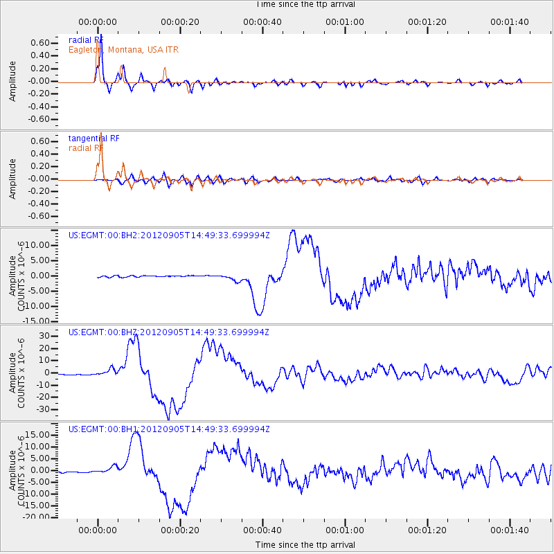
| Radial Match: |
98.16959 % |
| Radial Bump: |
356 |
| Transverse Match: |
81.461174 % |
| Transverse Bump: |
400 |
| SOD ConfigId: |
558545 |
| Insert Time: |
2013-09-17 15:52:39.054 +0000 |
| GWidth: |
2.5 |
| Max Bumps: |
400 |
| Tol: |
0.001 |
|
Signal To Noise
| Channel | StoN | STA | LTA |
| US:EGMT:00:BHZ:20120905T14:49:33.699994Z | 7.263699 | 2.9154314E-6 | 4.013701E-7 |
| US:EGMT:00:BH1:20120905T14:49:33.699994Z | 5.9779925 | 1.4978979E-6 | 2.505687E-7 |
| US:EGMT:00:BH2:20120905T14:49:33.699994Z | 5.1695695 | 1.1361227E-6 | 2.1977122E-7 |
| Arrivals |
| Ps | 6.2 SECOND |
| PpPs | 17 SECOND |
| PsPs/PpSs | 23 SECOND |


