You are here: Home > Network List > US - United States National Seismic Network Stations List
> Station ERPA Erie, Pennsylvania, USA > Earthquake Result Viewer
ERPA Erie, Pennsylvania, USA - Earthquake Result Viewer
| Earthquake location: |
Costa Rica |
| Earthquake latitude/longitude: |
10.1/-85.3 |
| Earthquake time(UTC): |
2012/09/05 (249) 14:42:07 GMT |
| Earthquake Depth: |
35 km |
| Earthquake Magnitude: |
7.6 MW, 6.8 MB, 7.6 MW, 7.7 MS |
| Earthquake Catalog/Contributor: |
NEIC PDE/NEIC PDE-W |
|
| Network: |
US United States National Seismic Network |
| Station: |
ERPA Erie, Pennsylvania, USA |
| Lat/Lon: |
42.12 N/79.99 W |
| Elevation: |
306 m |
|
| Distance: |
32.2 deg |
| Az: |
7.436 deg |
| Baz: |
189.863 deg |
| Ray Param: |
0.07867811 |
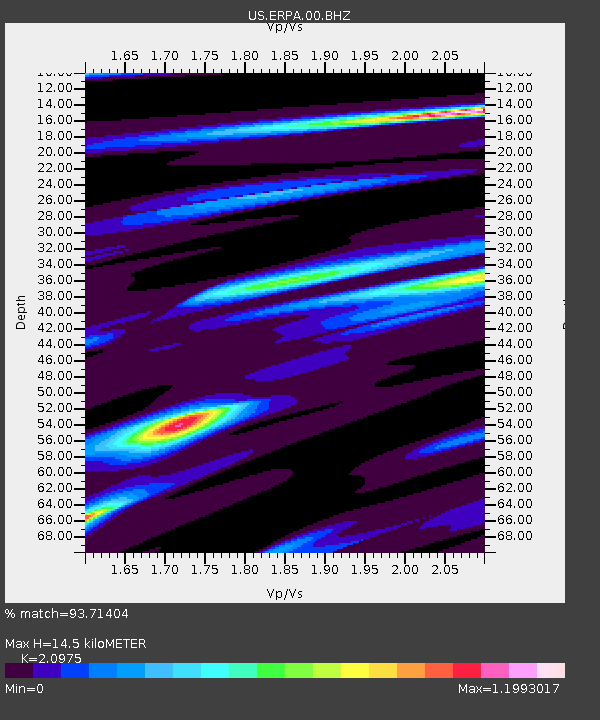
| Estimated Moho Depth: |
14.5 km |
| Estimated Crust Vp/Vs: |
2.10 |
| Assumed Crust Vp: |
6.419 km/s |
| Estimated Crust Vs: |
3.06 km/s |
| Estimated Crust Poisson's Ratio: |
0.35 |
|
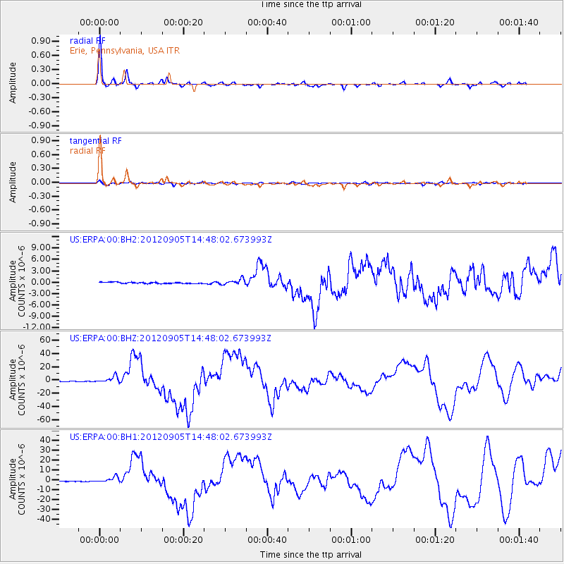
| Radial Match: |
93.71404 % |
| Radial Bump: |
299 |
| Transverse Match: |
70.022644 % |
| Transverse Bump: |
400 |
| SOD ConfigId: |
558545 |
| Insert Time: |
2013-09-17 15:52:42.981 +0000 |
| GWidth: |
2.5 |
| Max Bumps: |
400 |
| Tol: |
0.001 |
|
Signal To Noise
| Channel | StoN | STA | LTA |
| US:ERPA:00:BHZ:20120905T14:48:02.673993Z | 10.032169 | 4.862313E-6 | 4.8467217E-7 |
| US:ERPA:00:BH1:20120905T14:48:02.673993Z | 4.2529655 | 2.725299E-6 | 6.407997E-7 |
| US:ERPA:00:BH2:20120905T14:48:02.673993Z | 4.469008 | 7.578693E-7 | 1.6958333E-7 |
| Arrivals |
| Ps | 2.6 SECOND |
| PpPs | 6.5 SECOND |
| PsPs/PpSs | 9.2 SECOND |


