You are here: Home > Network List > US - United States National Seismic Network Stations List
> Station HAWA Hanford, Washington, USA > Earthquake Result Viewer
HAWA Hanford, Washington, USA - Earthquake Result Viewer
| Earthquake location: |
Costa Rica |
| Earthquake latitude/longitude: |
10.1/-85.3 |
| Earthquake time(UTC): |
2012/09/05 (249) 14:42:07 GMT |
| Earthquake Depth: |
35 km |
| Earthquake Magnitude: |
7.6 MW, 6.8 MB, 7.6 MW, 7.7 MS |
| Earthquake Catalog/Contributor: |
NEIC PDE/NEIC PDE-W |
|
| Network: |
US United States National Seismic Network |
| Station: |
HAWA Hanford, Washington, USA |
| Lat/Lon: |
46.39 N/119.53 W |
| Elevation: |
364 m |
|
| Distance: |
46.4 deg |
| Az: |
327.51 deg |
| Baz: |
130.161 deg |
| Ray Param: |
0.07057725 |
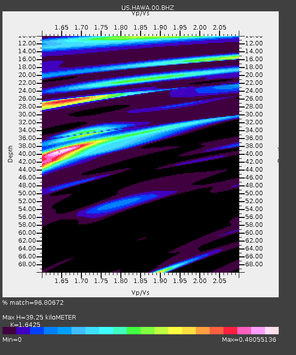
| Estimated Moho Depth: |
39.25 km |
| Estimated Crust Vp/Vs: |
1.64 |
| Assumed Crust Vp: |
6.419 km/s |
| Estimated Crust Vs: |
3.908 km/s |
| Estimated Crust Poisson's Ratio: |
0.21 |
|
| Radial Match: |
96.80672 % |
| Radial Bump: |
323 |
| Transverse Match: |
81.47308 % |
| Transverse Bump: |
400 |
| SOD ConfigId: |
558545 |
| Insert Time: |
2013-09-17 15:52:52.610 +0000 |
| GWidth: |
2.5 |
| Max Bumps: |
400 |
| Tol: |
0.001 |
|
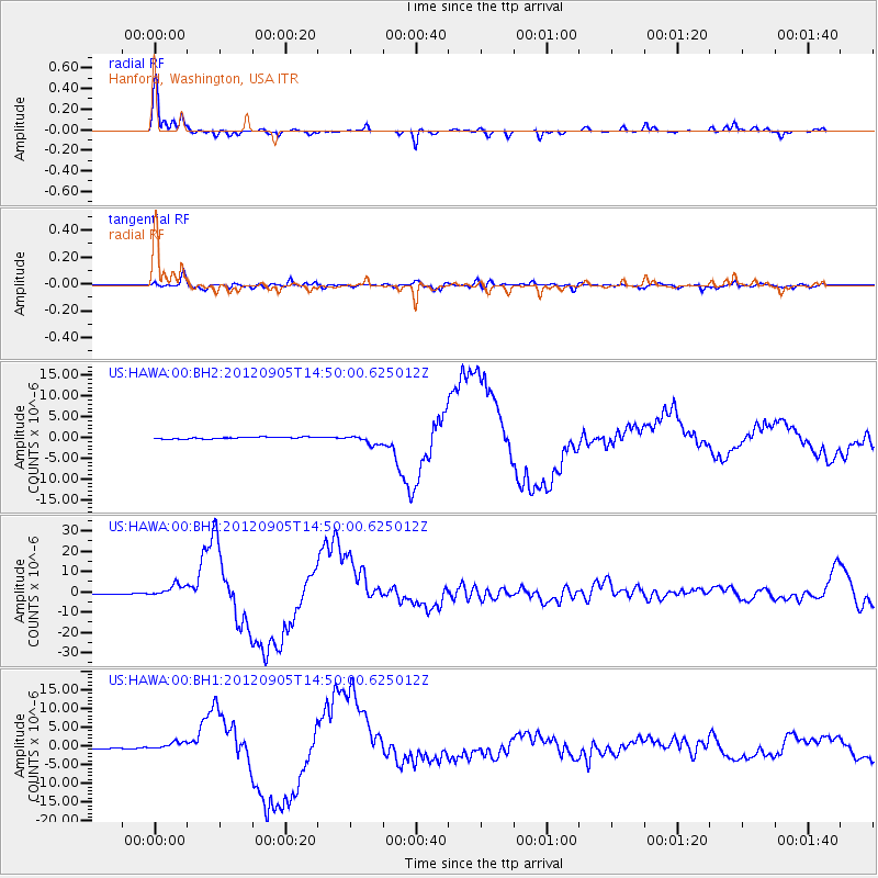
Signal To Noise
| Channel | StoN | STA | LTA |
| US:HAWA:00:BHZ:20120905T14:50:00.625012Z | 12.286808 | 2.9741307E-6 | 2.4205886E-7 |
| US:HAWA:00:BH1:20120905T14:50:00.625012Z | 5.5895343 | 1.0633235E-6 | 1.9023472E-7 |
| US:HAWA:00:BH2:20120905T14:50:00.625012Z | 5.6468945 | 1.15198E-6 | 2.0400239E-7 |
| Arrivals |
| Ps | 4.2 SECOND |
| PpPs | 15 SECOND |
| PsPs/PpSs | 19 SECOND |


