You are here: Home > Network List > US - United States National Seismic Network Stations List
> Station LONY Lake Ozonia, New York, USA > Earthquake Result Viewer
LONY Lake Ozonia, New York, USA - Earthquake Result Viewer
| Earthquake location: |
Costa Rica |
| Earthquake latitude/longitude: |
10.1/-85.3 |
| Earthquake time(UTC): |
2012/09/05 (249) 14:42:07 GMT |
| Earthquake Depth: |
35 km |
| Earthquake Magnitude: |
7.6 MW, 6.8 MB, 7.6 MW, 7.7 MS |
| Earthquake Catalog/Contributor: |
NEIC PDE/NEIC PDE-W |
|
| Network: |
US United States National Seismic Network |
| Station: |
LONY Lake Ozonia, New York, USA |
| Lat/Lon: |
44.62 N/74.58 W |
| Elevation: |
440 m |
|
| Distance: |
35.6 deg |
| Az: |
13.194 deg |
| Baz: |
198.345 deg |
| Ray Param: |
0.07704959 |
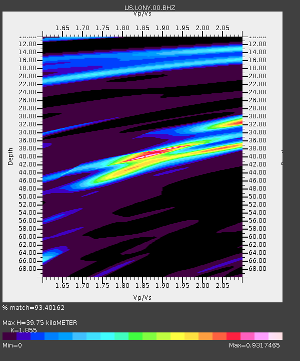
| Estimated Moho Depth: |
39.75 km |
| Estimated Crust Vp/Vs: |
1.86 |
| Assumed Crust Vp: |
6.419 km/s |
| Estimated Crust Vs: |
3.461 km/s |
| Estimated Crust Poisson's Ratio: |
0.30 |
|
| Radial Match: |
93.40162 % |
| Radial Bump: |
228 |
| Transverse Match: |
88.201935 % |
| Transverse Bump: |
301 |
| SOD ConfigId: |
558545 |
| Insert Time: |
2013-09-17 15:53:23.163 +0000 |
| GWidth: |
2.5 |
| Max Bumps: |
400 |
| Tol: |
0.001 |
|
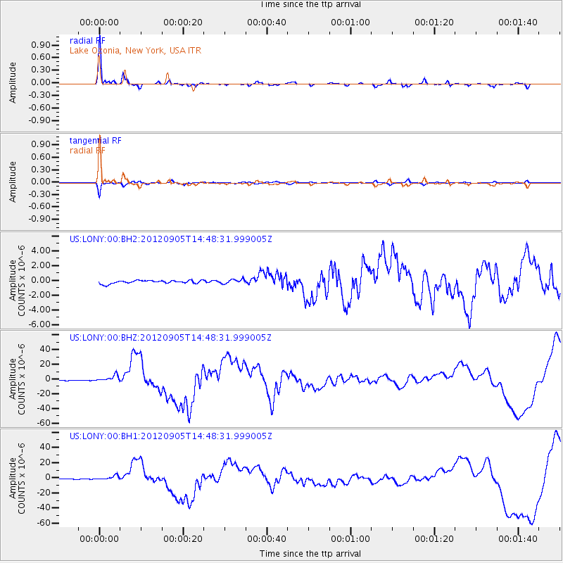
Signal To Noise
| Channel | StoN | STA | LTA |
| US:LONY:00:BHZ:20120905T14:48:31.999005Z | 7.5783014 | 4.1919293E-6 | 5.531489E-7 |
| US:LONY:00:BH1:20120905T14:48:31.999005Z | 3.7477365 | 2.5298243E-6 | 6.7502725E-7 |
| US:LONY:00:BH2:20120905T14:48:31.999005Z | 1.4363881 | 3.0376287E-7 | 2.1147687E-7 |
| Arrivals |
| Ps | 5.7 SECOND |
| PpPs | 16 SECOND |
| PsPs/PpSs | 22 SECOND |


