You are here: Home > Network List > US - United States National Seismic Network Stations List
> Station TPNV Topopah Spring, Nevada, USA > Earthquake Result Viewer
TPNV Topopah Spring, Nevada, USA - Earthquake Result Viewer
| Earthquake location: |
Costa Rica |
| Earthquake latitude/longitude: |
10.1/-85.3 |
| Earthquake time(UTC): |
2012/09/05 (249) 14:42:07 GMT |
| Earthquake Depth: |
35 km |
| Earthquake Magnitude: |
7.6 MW, 6.8 MB, 7.6 MW, 7.7 MS |
| Earthquake Catalog/Contributor: |
NEIC PDE/NEIC PDE-W |
|
| Network: |
US United States National Seismic Network |
| Station: |
TPNV Topopah Spring, Nevada, USA |
| Lat/Lon: |
36.95 N/116.25 W |
| Elevation: |
1600 m |
|
| Distance: |
38.7 deg |
| Az: |
318.766 deg |
| Baz: |
125.881 deg |
| Ray Param: |
0.07536056 |
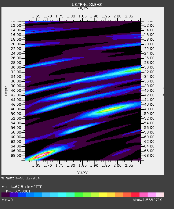
| Estimated Moho Depth: |
67.5 km |
| Estimated Crust Vp/Vs: |
1.68 |
| Assumed Crust Vp: |
6.279 km/s |
| Estimated Crust Vs: |
3.748 km/s |
| Estimated Crust Poisson's Ratio: |
0.22 |
|
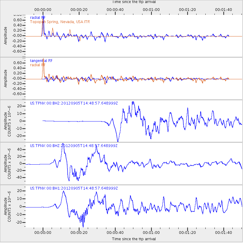
| Radial Match: |
96.327934 % |
| Radial Bump: |
365 |
| Transverse Match: |
87.518135 % |
| Transverse Bump: |
400 |
| SOD ConfigId: |
558545 |
| Insert Time: |
2013-09-17 15:53:52.113 +0000 |
| GWidth: |
2.5 |
| Max Bumps: |
400 |
| Tol: |
0.001 |
|
Signal To Noise
| Channel | StoN | STA | LTA |
| US:TPNV:00:BHZ:20120905T14:48:57.648999Z | 6.5696583 | 1.1760185E-6 | 1.7900754E-7 |
| US:TPNV:00:BH1:20120905T14:48:57.648999Z | 2.181211 | 4.6909068E-7 | 2.1505974E-7 |
| US:TPNV:00:BH2:20120905T14:48:57.648999Z | 2.1691425 | 5.29399E-7 | 2.4405915E-7 |
| Arrivals |
| Ps | 7.8 SECOND |
| PpPs | 27 SECOND |
| PsPs/PpSs | 35 SECOND |


