You are here: Home > Network List > II - Global Seismograph Network (GSN - IRIS/IDA) Stations List
> Station NIL Nilore, Pakistan > Earthquake Result Viewer
NIL Nilore, Pakistan - Earthquake Result Viewer

| Earthquake location: |
Philippine Islands Region |
| Earthquake latitude/longitude: |
10.4/126.7 |
| Earthquake time(UTC): |
2012/08/31 (244) 23:37:58 GMT |
| Earthquake Depth: |
40 km |
| Earthquake Magnitude: |
5.7 MB, 5.1 MS, 5.6 MW |
| Earthquake Catalog/Contributor: |
WHDF/NEIC |
|
| Network: |
II Global Seismograph Network (GSN - IRIS/IDA) |
| Station: |
NIL Nilore, Pakistan |
| Lat/Lon: |
33.65 N/73.27 E |
| Elevation: |
629 m |
|
| Distance: |
54.0 deg |
| Az: |
304.097 deg |
| Baz: |
102.396 deg |
| Ray Param: |
0.06562752 |
| Estimated Moho Depth: |
51.25 km |
| Estimated Crust Vp/Vs: |
1.70 |
| Assumed Crust Vp: |
6.242 km/s |
| Estimated Crust Vs: |
3.677 km/s |
| Estimated Crust Poisson's Ratio: |
0.23 |
|
| Radial Match: |
87.31021 % |
| Radial Bump: |
400 |
| Transverse Match: |
68.0469 % |
| Transverse Bump: |
400 |
| SOD ConfigId: |
558545 |
| Insert Time: |
2013-09-17 15:59:56.523 +0000 |
| GWidth: |
2.5 |
| Max Bumps: |
400 |
| Tol: |
0.001 |
|
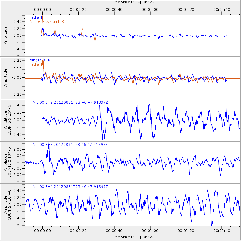
Signal To Noise
| Channel | StoN | STA | LTA |
| II:NIL:00:BHZ:20120831T23:46:47.91897Z | 9.155741 | 1.3409003E-6 | 1.464546E-7 |
| II:NIL:00:BH1:20120831T23:46:47.91897Z | 1.4717063 | 1.5830737E-7 | 1.0756723E-7 |
| II:NIL:00:BH2:20120831T23:46:47.91897Z | 4.902255 | 2.719835E-7 | 5.5481305E-8 |
| Arrivals |
| Ps | 6.0 SECOND |
| PpPs | 21 SECOND |
| PsPs/PpSs | 27 SECOND |


