You are here: Home > Network List > IU - Global Seismograph Network (GSN - IRIS/USGS) Stations List
> Station GNI Garni, Armenia > Earthquake Result Viewer
GNI Garni, Armenia - Earthquake Result Viewer
| Earthquake location: |
Philippine Islands Region |
| Earthquake latitude/longitude: |
10.4/126.7 |
| Earthquake time(UTC): |
2012/08/31 (244) 23:37:58 GMT |
| Earthquake Depth: |
40 km |
| Earthquake Magnitude: |
5.7 MB, 5.1 MS, 5.6 MW |
| Earthquake Catalog/Contributor: |
WHDF/NEIC |
|
| Network: |
IU Global Seismograph Network (GSN - IRIS/USGS) |
| Station: |
GNI Garni, Armenia |
| Lat/Lon: |
40.15 N/44.74 E |
| Elevation: |
1609 m |
|
| Distance: |
77.3 deg |
| Az: |
308.911 deg |
| Baz: |
87.112 deg |
| Ray Param: |
0.050368767 |
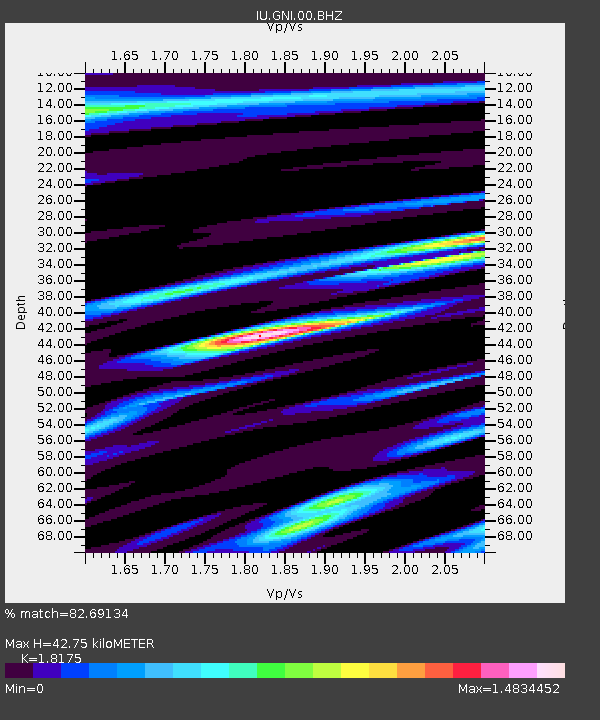
| Estimated Moho Depth: |
42.75 km |
| Estimated Crust Vp/Vs: |
1.82 |
| Assumed Crust Vp: |
6.291 km/s |
| Estimated Crust Vs: |
3.461 km/s |
| Estimated Crust Poisson's Ratio: |
0.28 |
|
| Radial Match: |
82.69134 % |
| Radial Bump: |
380 |
| Transverse Match: |
75.95415 % |
| Transverse Bump: |
400 |
| SOD ConfigId: |
558545 |
| Insert Time: |
2013-09-17 16:00:34.645 +0000 |
| GWidth: |
2.5 |
| Max Bumps: |
400 |
| Tol: |
0.001 |
|
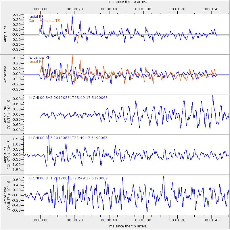
Signal To Noise
| Channel | StoN | STA | LTA |
| IU:GNI:00:BHZ:20120831T23:49:17.519006Z | 8.28533 | 7.1204744E-7 | 8.594075E-8 |
| IU:GNI:00:BH1:20120831T23:49:17.519006Z | 2.0650485 | 1.10384825E-7 | 5.3453867E-8 |
| IU:GNI:00:BH2:20120831T23:49:17.519006Z | 0.91458046 | 7.740253E-8 | 8.4631736E-8 |
| Arrivals |
| Ps | 5.7 SECOND |
| PpPs | 19 SECOND |
| PsPs/PpSs | 24 SECOND |


