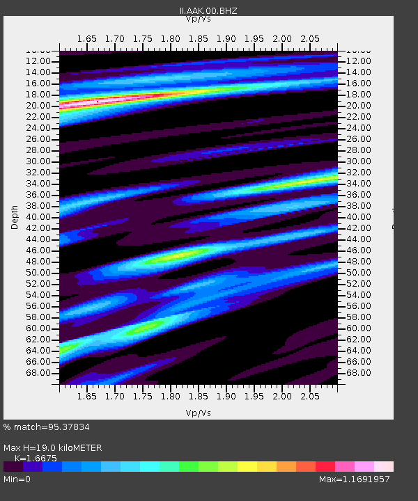
AAK Ala Archa, Kyrgyzstan - Earthquake Result Viewer

Earthquake location: Philippine Islands Region
Earthquake latitude/longitude: 10.8/126.6
Earthquake time(UTC): 2012/08/31 (244) 12:47:33 GMT
Earthquake Depth: 28 km
Earthquake Magnitude: 7.6 MW, 7.2 MB, 7.6 MS, 7.6 MW
Earthquake Catalog/Contributor: NEIC PDE/NEIC PDE-W
Network: II Global Seismograph Network (GSN - IRIS/IDA)
Station: AAK Ala Archa, Kyrgyzstan
Lat/Lon: 42.64 N/74.49 E
Elevation: 1645 m
Distance: 55.2 deg
Az: 314.807 deg
Baz: 109.152 deg
Ray Param: 0.06490148
Estimated Moho Depth: 19.0 km
Estimated Crust Vp/Vs: 1.67
Assumed Crust Vp: 6.306 km/s
Estimated Crust Vs: 3.782 km/s
Estimated Crust Poisson's Ratio: 0.22
Radial Match: 95.37834 %
Radial Bump: 396
Transverse Match: 89.09324 %
Transverse Bump: 400
SOD ConfigId: 558545
Insert Time: 2013-09-17 16:01:43.407 +0000
GWidth: 2.5
Max Bumps: 400
Tol: 0.001

Signal To Noise

ChannelStoNSTALTA
II:AAK:00:BHZ:20120831T12:56:32.819026Z25.8758342.206679E-68.527954E-8
II:AAK:00:BH1:20120831T12:56:32.819026Z2.61079651.3341511E-75.1101313E-8
II:AAK:00:BH2:20120831T12:56:32.819026Z20.1985151.0391886E-65.144876E-8
Arrivals
Ps2.1 SECOND
PpPs7.6 SECOND
PsPs/PpSs9.7 SECOND