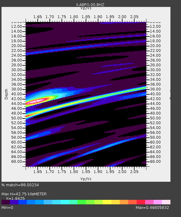
ABPO Ambohimpanompo, Madagascar - Earthquake Result Viewer
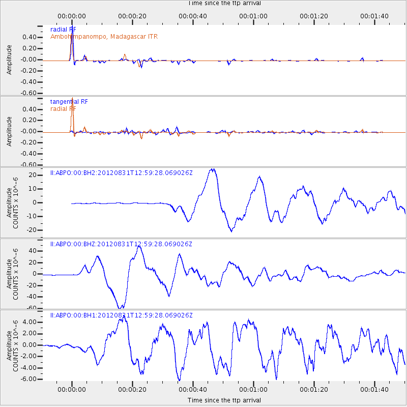
Earthquake location: Philippine Islands Region
Earthquake latitude/longitude: 10.8/126.6
Earthquake time(UTC): 2012/08/31 (244) 12:47:33 GMT
Earthquake Depth: 28 km
Earthquake Magnitude: 7.6 MW, 7.2 MB, 7.6 MS, 7.6 MW
Earthquake Catalog/Contributor: NEIC PDE/NEIC PDE-W
Network: II Global Seismograph Network (GSN - IRIS/IDA)
Station: ABPO Ambohimpanompo, Madagascar
Lat/Lon: 19.02 S/47.23 E
Elevation: 1528 m
Distance: 83.7 deg
Az: 249.341 deg
Baz: 76.335 deg
Ray Param: 0.045998137
Estimated Moho Depth: 42.75 km
Estimated Crust Vp/Vs: 1.64
Assumed Crust Vp: 6.642 km/s
Estimated Crust Vs: 4.044 km/s
Estimated Crust Poisson's Ratio: 0.21
Radial Match: 99.00234 %
Radial Bump: 173
Transverse Match: 95.19107 %
Transverse Bump: 400
SOD ConfigId: 558545
Insert Time: 2013-09-17 16:01:48.500 +0000
GWidth: 2.5
Max Bumps: 400
Tol: 0.001

Signal To Noise

ChannelStoNSTALTA
II:ABPO:00:BHZ:20120831T12:59:28.069026Z32.4704637.357252E-62.2658291E-7
II:ABPO:00:BH1:20120831T12:59:28.069026Z3.26437145.4594267E-71.6724283E-7
II:ABPO:00:BH2:20120831T12:59:28.069026Z12.4901072.6993341E-62.1611778E-7
Arrivals
Ps4.3 SECOND
PpPs17 SECOND
PsPs/PpSs21 SECOND