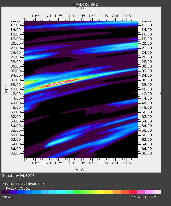
PALK Pallekele, Sri Lanka - Earthquake Result Viewer
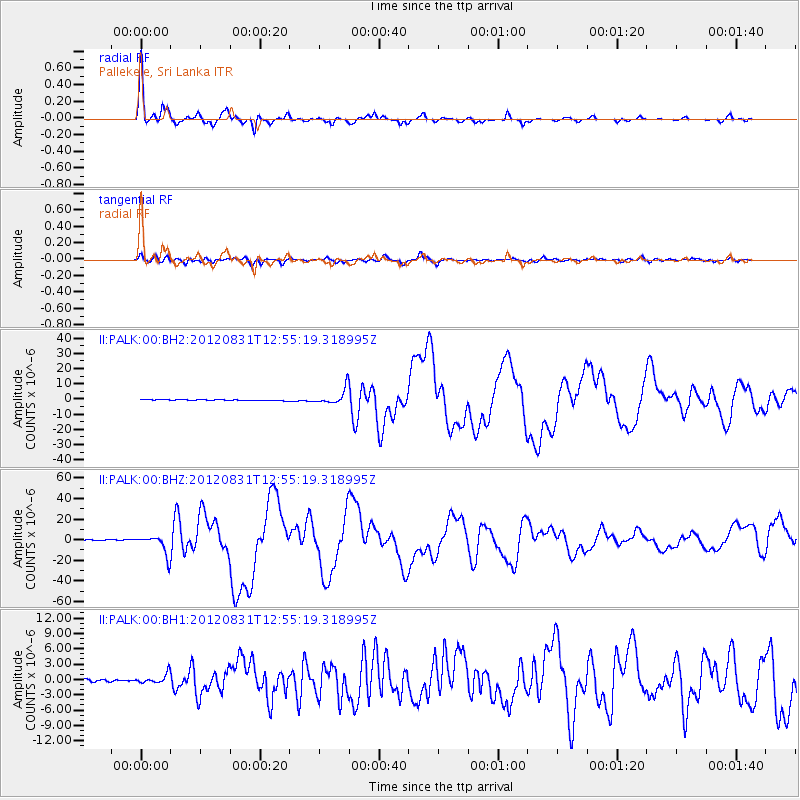
Earthquake location: Philippine Islands Region
Earthquake latitude/longitude: 10.8/126.6
Earthquake time(UTC): 2012/08/31 (244) 12:47:33 GMT
Earthquake Depth: 28 km
Earthquake Magnitude: 7.6 MW, 7.2 MB, 7.6 MS, 7.6 MW
Earthquake Catalog/Contributor: NEIC PDE/NEIC PDE-W
Network: II Global Seismograph Network (GSN - IRIS/IDA)
Station: PALK Pallekele, Sri Lanka
Lat/Lon: 7.27 N/80.70 E
Elevation: 460 m
Distance: 45.5 deg
Az: 269.597 deg
Baz: 82.021 deg
Ray Param: 0.07120545
Estimated Moho Depth: 37.25 km
Estimated Crust Vp/Vs: 1.75
Assumed Crust Vp: 6.545 km/s
Estimated Crust Vs: 3.746 km/s
Estimated Crust Poisson's Ratio: 0.26
Radial Match: 96.3077 %
Radial Bump: 323
Transverse Match: 87.96214 %
Transverse Bump: 400
SOD ConfigId: 558545
Insert Time: 2013-09-17 16:02:08.109 +0000
GWidth: 2.5
Max Bumps: 400
Tol: 0.001

Signal To Noise

ChannelStoNSTALTA
II:PALK:00:BHZ:20120831T12:55:19.318995Z17.7765259.3253775E-65.2458944E-7
II:PALK:00:BH1:20120831T12:55:19.318995Z2.71638979.2720876E-73.4133865E-7
II:PALK:00:BH2:20120831T12:55:19.318995Z15.3458955.1764646E-63.373192E-7
Arrivals
Ps4.5 SECOND
PpPs15 SECOND
PsPs/PpSs19 SECOND